You are here: Home > Network List > BK - Berkeley Digital Seismograph Network Stations List
> Station SAO San Andreas Geophysical Obs., Hollister, CA, USA > Earthquake Result Viewer
SAO San Andreas Geophysical Obs., Hollister, CA, USA - Earthquake Result Viewer

| Earthquake location: |
Southeast Of Loyalty Islands |
| Earthquake latitude/longitude: |
-22.6/170.9 |
| Earthquake time(UTC): |
2009/01/19 (019) 03:35:18 GMT |
| Earthquake Depth: |
12 km |
| Earthquake Magnitude: |
5.7 MB, 6.4 MS, 6.5 MW, 6.5 MW |
| Earthquake Catalog/Contributor: |
WHDF/NEIC |
|
| Network: |
BK Berkeley Digital Seismograph Network |
| Station: |
SAO San Andreas Geophysical Obs., Hollister, CA, USA |
| Lat/Lon: |
36.76 N/121.45 W |
| Elevation: |
317 m |
|
| Distance: |
86.9 deg |
| Az: |
48.054 deg |
| Baz: |
238.865 deg |
| Ray Param: |
0.04373423 |
| Estimated Moho Depth: |
29.0 km |
| Estimated Crust Vp/Vs: |
1.66 |
| Assumed Crust Vp: |
6.391 km/s |
| Estimated Crust Vs: |
3.856 km/s |
| Estimated Crust Poisson's Ratio: |
0.21 |
|
| Radial Match: |
83.77819 % |
| Radial Bump: |
400 |
| Transverse Match: |
74.521484 % |
| Transverse Bump: |
330 |
| SOD ConfigId: |
2658 |
| Insert Time: |
2010-03-05 19:53:30.704 +0000 |
| GWidth: |
2.5 |
| Max Bumps: |
400 |
| Tol: |
0.001 |
|
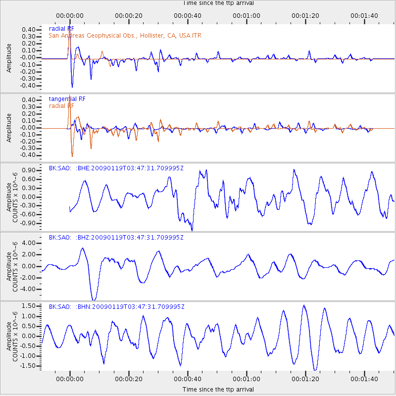
Signal To Noise
| Channel | StoN | STA | LTA |
| BK:SAO: :BHZ:20090119T03:47:31.709995Z | 4.005003 | 1.5831835E-6 | 3.953014E-7 |
| BK:SAO: :BHN:20090119T03:47:31.709995Z | 0.9284937 | 3.2228775E-7 | 3.4710817E-7 |
| BK:SAO: :BHE:20090119T03:47:31.709995Z | 1.4569262 | 3.997677E-7 | 2.7439117E-7 |
| Arrivals |
| Ps | 3.1 SECOND |
| PpPs | 12 SECOND |
| PsPs/PpSs | 15 SECOND |


