You are here: Home > Network List > BK - Berkeley Digital Seismograph Network Stations List
> Station SAO San Andreas Geophysical Obs., Hollister, CA, USA > Earthquake Result Viewer
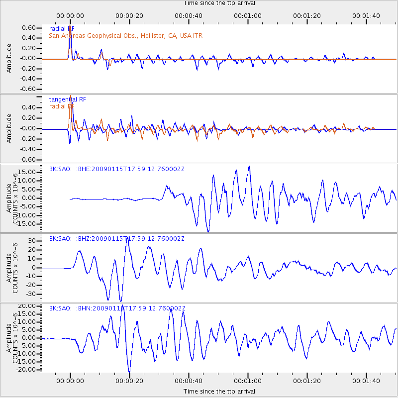
SAO San Andreas Geophysical Obs., Hollister, CA, USA - Earthquake Result Viewer
*The percent match for this event was below the threshold and hence no stack was calculated.
| Earthquake location: |
East Of Kuril Islands |
| Earthquake latitude/longitude: |
46.9/155.2 |
| Earthquake time(UTC): |
2009/01/15 (015) 17:49:39 GMT |
| Earthquake Depth: |
36 km |
| Earthquake Magnitude: |
6.9 MB, 7.5 MS, 7.4 MW, 7.4 MW |
| Earthquake Catalog/Contributor: |
WHDF/NEIC |
|
| Network: |
BK Berkeley Digital Seismograph Network |
| Station: |
SAO San Andreas Geophysical Obs., Hollister, CA, USA |
| Lat/Lon: |
36.76 N/121.45 W |
| Elevation: |
317 m |
|
| Distance: |
60.2 deg |
| Az: |
66.804 deg |
| Baz: |
308.232 deg |
| Ray Param: |
$rayparam |
*The percent match for this event was below the threshold and hence was not used in the summary stack. |
|
| Radial Match: |
95.56683 % |
| Radial Bump: |
400 |
| Transverse Match: |
94.667244 % |
| Transverse Bump: |
400 |
| SOD ConfigId: |
2834 |
| Insert Time: |
2010-03-05 19:53:47.675 +0000 |
| GWidth: |
2.5 |
| Max Bumps: |
400 |
| Tol: |
0.001 |
|
Signal To Noise
| Channel | StoN | STA | LTA |
| BK:SAO: :BHZ:20090115T17:59:12.760002Z | 75.79721 | 1.1226438E-5 | 1.4811148E-7 |
| BK:SAO: :BHN:20090115T17:59:12.760002Z | 24.246231 | 4.73324E-6 | 1.952155E-7 |
| BK:SAO: :BHE:20090115T17:59:12.760002Z | 15.273976 | 4.0172195E-6 | 2.6301072E-7 |
| Arrivals |
| Ps | |
| PpPs | |
| PsPs/PpSs | |


