You are here: Home > Network List > CI - Caltech Regional Seismic Network Stations List
> Station BAR Barrett, Tecate, CA, USA > Earthquake Result Viewer
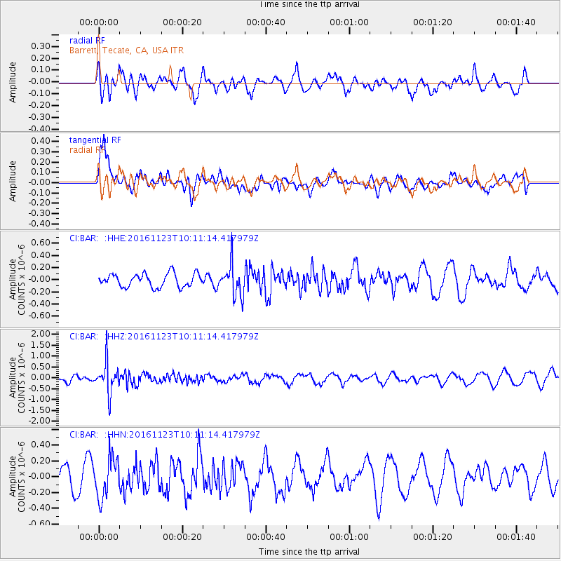
BAR Barrett, Tecate, CA, USA - Earthquake Result Viewer
*The percent match for this event was below the threshold and hence no stack was calculated.
| Earthquake location: |
Bonin Islands, Japan Region |
| Earthquake latitude/longitude: |
27.2/140.0 |
| Earthquake time(UTC): |
2016/11/23 (328) 09:59:56 GMT |
| Earthquake Depth: |
477 km |
| Earthquake Magnitude: |
5.7 MB |
| Earthquake Catalog/Contributor: |
NEIC PDE/NEIC COMCAT |
|
| Network: |
CI Caltech Regional Seismic Network |
| Station: |
BAR Barrett, Tecate, CA, USA |
| Lat/Lon: |
32.68 N/116.67 W |
| Elevation: |
521 m |
|
| Distance: |
85.9 deg |
| Az: |
55.365 deg |
| Baz: |
299.622 deg |
| Ray Param: |
$rayparam |
*The percent match for this event was below the threshold and hence was not used in the summary stack. |
|
| Radial Match: |
77.97375 % |
| Radial Bump: |
400 |
| Transverse Match: |
63.218395 % |
| Transverse Bump: |
400 |
| SOD ConfigId: |
11737051 |
| Insert Time: |
2019-04-26 03:24:41.918 +0000 |
| GWidth: |
2.5 |
| Max Bumps: |
400 |
| Tol: |
0.001 |
|
Signal To Noise
| Channel | StoN | STA | LTA |
| CI:BAR: :HHZ:20161123T10:11:14.417979Z | 3.0948536 | 7.0201884E-7 | 2.2683427E-7 |
| CI:BAR: :HHN:20161123T10:11:14.417979Z | 1.0080304 | 2.5971616E-7 | 2.5764714E-7 |
| CI:BAR: :HHE:20161123T10:11:14.417979Z | 2.4725695 | 2.7033013E-7 | 1.09331665E-7 |
| Arrivals |
| Ps | |
| PpPs | |
| PsPs/PpSs | |


