You are here: Home > Network List > TA - USArray Transportable Network (new EarthScope stations) Stations List
> Station A36M Sachs Harbour, NT, CAN > Earthquake Result Viewer
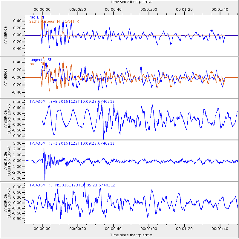
A36M Sachs Harbour, NT, CAN - Earthquake Result Viewer
*The percent match for this event was below the threshold and hence no stack was calculated.
| Earthquake location: |
Bonin Islands, Japan Region |
| Earthquake latitude/longitude: |
27.2/140.0 |
| Earthquake time(UTC): |
2016/11/23 (328) 09:59:56 GMT |
| Earthquake Depth: |
477 km |
| Earthquake Magnitude: |
5.7 MB |
| Earthquake Catalog/Contributor: |
NEIC PDE/NEIC COMCAT |
|
| Network: |
TA USArray Transportable Network (new EarthScope stations) |
| Station: |
A36M Sachs Harbour, NT, CAN |
| Lat/Lon: |
71.99 N/125.25 W |
| Elevation: |
32 m |
|
| Distance: |
65.9 deg |
| Az: |
19.859 deg |
| Baz: |
283.368 deg |
| Ray Param: |
$rayparam |
*The percent match for this event was below the threshold and hence was not used in the summary stack. |
|
| Radial Match: |
48.240402 % |
| Radial Bump: |
400 |
| Transverse Match: |
61.68002 % |
| Transverse Bump: |
400 |
| SOD ConfigId: |
11737051 |
| Insert Time: |
2019-04-26 03:29:17.196 +0000 |
| GWidth: |
2.5 |
| Max Bumps: |
400 |
| Tol: |
0.001 |
|
Signal To Noise
| Channel | StoN | STA | LTA |
| TA:A36M: :BHZ:20161123T10:09:23.674021Z | 8.036056 | 1.070034E-6 | 1.3315415E-7 |
| TA:A36M: :BHN:20161123T10:09:23.674021Z | 1.3404361 | 2.1909626E-7 | 1.6345147E-7 |
| TA:A36M: :BHE:20161123T10:09:23.674021Z | 1.402861 | 5.4298357E-7 | 3.8705446E-7 |
| Arrivals |
| Ps | |
| PpPs | |
| PsPs/PpSs | |


