You are here: Home > Network List > TA - USArray Transportable Network (new EarthScope stations) Stations List
> Station D25K Kavik River, AK, USA > Earthquake Result Viewer
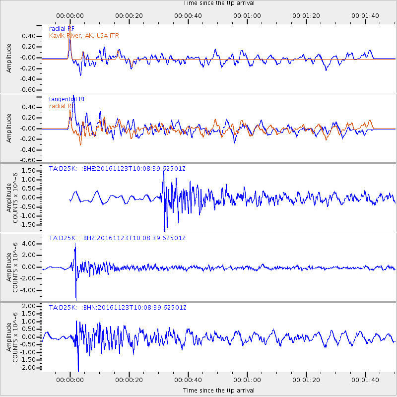
D25K Kavik River, AK, USA - Earthquake Result Viewer
*The percent match for this event was below the threshold and hence no stack was calculated.
| Earthquake location: |
Bonin Islands, Japan Region |
| Earthquake latitude/longitude: |
27.2/140.0 |
| Earthquake time(UTC): |
2016/11/23 (328) 09:59:56 GMT |
| Earthquake Depth: |
477 km |
| Earthquake Magnitude: |
5.7 MB |
| Earthquake Catalog/Contributor: |
NEIC PDE/NEIC COMCAT |
|
| Network: |
TA USArray Transportable Network (new EarthScope stations) |
| Station: |
D25K Kavik River, AK, USA |
| Lat/Lon: |
69.32 N/146.38 W |
| Elevation: |
770 m |
|
| Distance: |
59.1 deg |
| Az: |
23.401 deg |
| Baz: |
265.057 deg |
| Ray Param: |
$rayparam |
*The percent match for this event was below the threshold and hence was not used in the summary stack. |
|
| Radial Match: |
58.859722 % |
| Radial Bump: |
400 |
| Transverse Match: |
80.52072 % |
| Transverse Bump: |
400 |
| SOD ConfigId: |
11737051 |
| Insert Time: |
2019-04-26 03:29:22.942 +0000 |
| GWidth: |
2.5 |
| Max Bumps: |
400 |
| Tol: |
0.001 |
|
Signal To Noise
| Channel | StoN | STA | LTA |
| TA:D25K: :BHZ:20161123T10:08:39.62501Z | 8.797306 | 1.4663879E-6 | 1.6668601E-7 |
| TA:D25K: :BHN:20161123T10:08:39.62501Z | 3.1736407 | 5.609751E-7 | 1.7676074E-7 |
| TA:D25K: :BHE:20161123T10:08:39.62501Z | 3.883517 | 6.837845E-7 | 1.7607351E-7 |
| Arrivals |
| Ps | |
| PpPs | |
| PsPs/PpSs | |


