You are here: Home > Network List > TA - USArray Transportable Network (new EarthScope stations) Stations List
> Station M31M Drury Creek, Yukon, CA > Earthquake Result Viewer
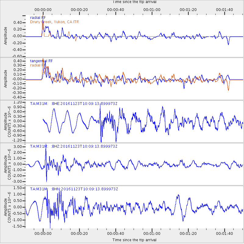
M31M Drury Creek, Yukon, CA - Earthquake Result Viewer
*The percent match for this event was below the threshold and hence no stack was calculated.
| Earthquake location: |
Bonin Islands, Japan Region |
| Earthquake latitude/longitude: |
27.2/140.0 |
| Earthquake time(UTC): |
2016/11/23 (328) 09:59:56 GMT |
| Earthquake Depth: |
477 km |
| Earthquake Magnitude: |
5.7 MB |
| Earthquake Catalog/Contributor: |
NEIC PDE/NEIC COMCAT |
|
| Network: |
TA USArray Transportable Network (new EarthScope stations) |
| Station: |
M31M Drury Creek, Yukon, CA |
| Lat/Lon: |
62.20 N/134.39 W |
| Elevation: |
639 m |
|
| Distance: |
64.3 deg |
| Az: |
31.238 deg |
| Baz: |
279.723 deg |
| Ray Param: |
$rayparam |
*The percent match for this event was below the threshold and hence was not used in the summary stack. |
|
| Radial Match: |
50.452343 % |
| Radial Bump: |
400 |
| Transverse Match: |
56.656666 % |
| Transverse Bump: |
400 |
| SOD ConfigId: |
11737051 |
| Insert Time: |
2019-04-26 03:29:59.194 +0000 |
| GWidth: |
2.5 |
| Max Bumps: |
400 |
| Tol: |
0.001 |
|
Signal To Noise
| Channel | StoN | STA | LTA |
| TA:M31M: :BHZ:20161123T10:09:13.899973Z | 4.021592 | 1.0583786E-6 | 2.6317403E-7 |
| TA:M31M: :BHN:20161123T10:09:13.899973Z | 2.1316094 | 6.3513096E-7 | 2.9795842E-7 |
| TA:M31M: :BHE:20161123T10:09:13.899973Z | 1.0999874 | 4.609694E-7 | 4.1906793E-7 |
| Arrivals |
| Ps | |
| PpPs | |
| PsPs/PpSs | |


