You are here: Home > Network List > WY - Yellowstone Wyoming Seismic Network Stations List
> Station YHH Holmes Hill, YNP, WY, USA > Earthquake Result Viewer
YHH Holmes Hill, YNP, WY, USA - Earthquake Result Viewer
| Earthquake location: |
Tonga Islands |
| Earthquake latitude/longitude: |
-16.3/-173.2 |
| Earthquake time(UTC): |
2015/10/18 (291) 16:18:35 GMT |
| Earthquake Depth: |
10 km |
| Earthquake Magnitude: |
5.9 MWB |
| Earthquake Catalog/Contributor: |
NEIC PDE/NEIC COMCAT |
|
| Network: |
WY Yellowstone Wyoming Seismic Network |
| Station: |
YHH Holmes Hill, YNP, WY, USA |
| Lat/Lon: |
44.79 N/110.85 W |
| Elevation: |
2717 m |
|
| Distance: |
83.0 deg |
| Az: |
39.452 deg |
| Baz: |
238.998 deg |
| Ray Param: |
0.046512574 |
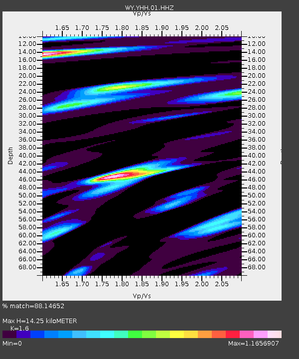
| Estimated Moho Depth: |
14.25 km |
| Estimated Crust Vp/Vs: |
1.60 |
| Assumed Crust Vp: |
6.35 km/s |
| Estimated Crust Vs: |
3.969 km/s |
| Estimated Crust Poisson's Ratio: |
0.18 |
|
| Radial Match: |
88.14652 % |
| Radial Bump: |
400 |
| Transverse Match: |
86.60568 % |
| Transverse Bump: |
400 |
| SOD ConfigId: |
1259291 |
| Insert Time: |
2015-11-01 16:45:28.267 +0000 |
| GWidth: |
2.5 |
| Max Bumps: |
400 |
| Tol: |
0.001 |
|
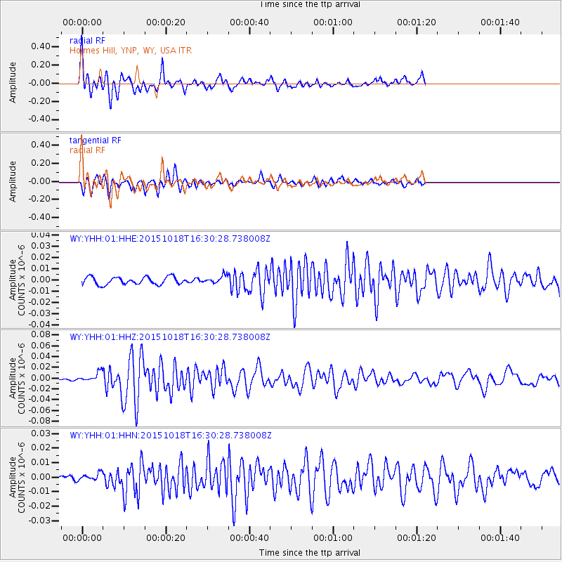
Signal To Noise
| Channel | StoN | STA | LTA |
| WY:YHH:01:HHZ:20151018T16:30:28.738008Z | 2.881686 | 8.903975E-9 | 3.089849E-9 |
| WY:YHH:01:HHN:20151018T16:30:28.738008Z | 0.97457343 | 2.6905733E-9 | 2.7607703E-9 |
| WY:YHH:01:HHE:20151018T16:30:28.738008Z | 1.0533535 | 3.5095804E-9 | 3.3318164E-9 |
| Arrivals |
| Ps | 1.4 SECOND |
| PpPs | 5.7 SECOND |
| PsPs/PpSs | 7.1 SECOND |


