You are here: Home > Network List > TA - USArray Transportable Network (new EarthScope stations) Stations List
> Station T25A Trinidad, CO, USA > Earthquake Result Viewer
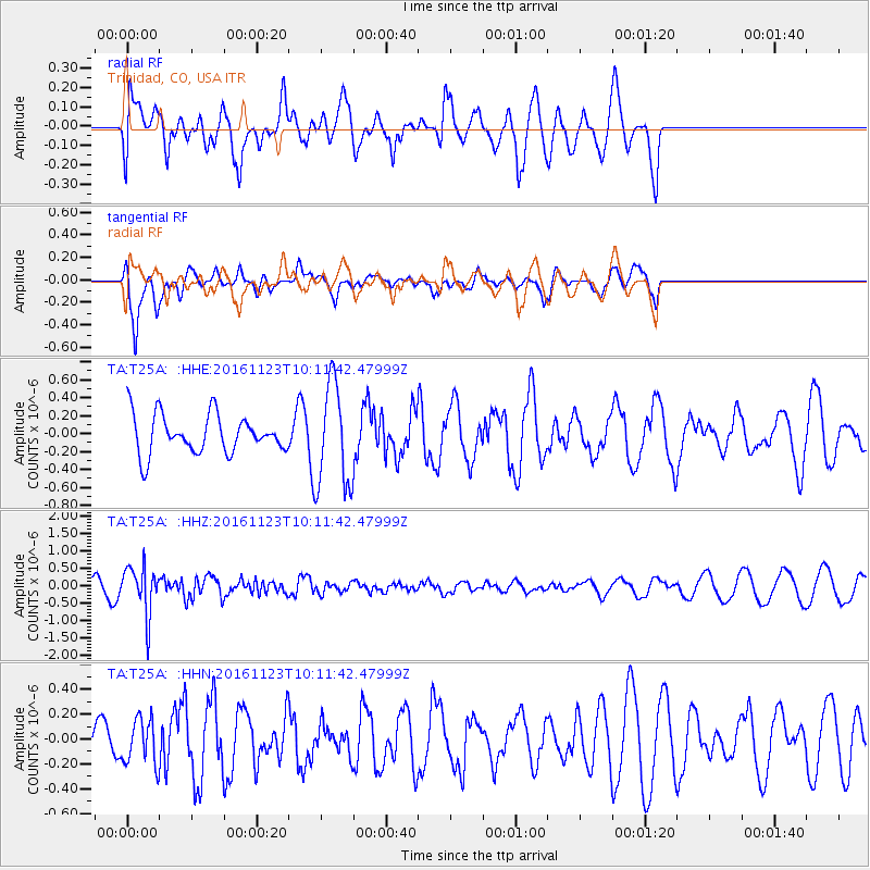
T25A Trinidad, CO, USA - Earthquake Result Viewer
*The percent match for this event was below the threshold and hence no stack was calculated.
| Earthquake location: |
Bonin Islands, Japan Region |
| Earthquake latitude/longitude: |
27.2/140.0 |
| Earthquake time(UTC): |
2016/11/23 (328) 09:59:56 GMT |
| Earthquake Depth: |
477 km |
| Earthquake Magnitude: |
5.7 MB |
| Earthquake Catalog/Contributor: |
NEIC PDE/NEIC COMCAT |
|
| Network: |
TA USArray Transportable Network (new EarthScope stations) |
| Station: |
T25A Trinidad, CO, USA |
| Lat/Lon: |
37.14 N/104.41 W |
| Elevation: |
2017 m |
|
| Distance: |
92.0 deg |
| Az: |
46.163 deg |
| Baz: |
306.461 deg |
| Ray Param: |
$rayparam |
*The percent match for this event was below the threshold and hence was not used in the summary stack. |
|
| Radial Match: |
63.337387 % |
| Radial Bump: |
398 |
| Transverse Match: |
84.67272 % |
| Transverse Bump: |
400 |
| SOD ConfigId: |
11737051 |
| Insert Time: |
2019-04-26 03:30:39.162 +0000 |
| GWidth: |
2.5 |
| Max Bumps: |
400 |
| Tol: |
0.001 |
|
Signal To Noise
| Channel | StoN | STA | LTA |
| TA:T25A: :HHZ:20161123T10:11:42.47999Z | 4.031808 | 6.826495E-7 | 1.6931598E-7 |
| TA:T25A: :HHN:20161123T10:11:42.47999Z | 0.6842757 | 1.828954E-7 | 2.672832E-7 |
| TA:T25A: :HHE:20161123T10:11:42.47999Z | 2.679669 | 5.7921267E-7 | 2.1615084E-7 |
| Arrivals |
| Ps | |
| PpPs | |
| PsPs/PpSs | |


