You are here: Home > Network List > WY - Yellowstone Wyoming Seismic Network Stations List
> Station YTP The Promontory, YNP, WY, USA > Earthquake Result Viewer
YTP The Promontory, YNP, WY, USA - Earthquake Result Viewer
| Earthquake location: |
Tonga Islands |
| Earthquake latitude/longitude: |
-16.3/-173.2 |
| Earthquake time(UTC): |
2015/10/18 (291) 16:18:35 GMT |
| Earthquake Depth: |
10 km |
| Earthquake Magnitude: |
5.9 MWB |
| Earthquake Catalog/Contributor: |
NEIC PDE/NEIC COMCAT |
|
| Network: |
WY Yellowstone Wyoming Seismic Network |
| Station: |
YTP The Promontory, YNP, WY, USA |
| Lat/Lon: |
44.39 N/110.29 W |
| Elevation: |
2384 m |
|
| Distance: |
83.1 deg |
| Az: |
40.004 deg |
| Baz: |
239.46 deg |
| Ray Param: |
0.04641223 |
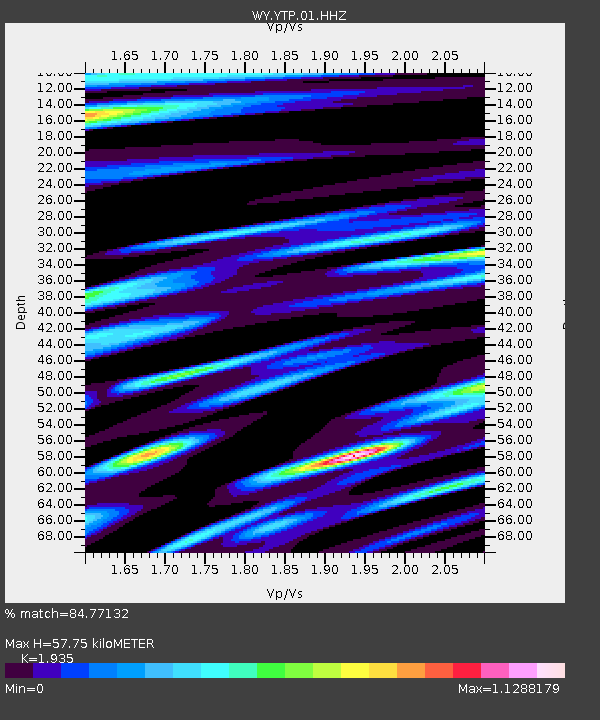
| Estimated Moho Depth: |
57.75 km |
| Estimated Crust Vp/Vs: |
1.93 |
| Assumed Crust Vp: |
6.35 km/s |
| Estimated Crust Vs: |
3.282 km/s |
| Estimated Crust Poisson's Ratio: |
0.32 |
|
| Radial Match: |
84.77132 % |
| Radial Bump: |
322 |
| Transverse Match: |
82.416885 % |
| Transverse Bump: |
334 |
| SOD ConfigId: |
1259291 |
| Insert Time: |
2015-11-01 16:45:53.138 +0000 |
| GWidth: |
2.5 |
| Max Bumps: |
400 |
| Tol: |
0.001 |
|

Signal To Noise
| Channel | StoN | STA | LTA |
| WY:YTP:01:HHZ:20151018T16:30:29.488008Z | 3.6200695 | 1.1528229E-8 | 3.1845324E-9 |
| WY:YTP:01:HHN:20151018T16:30:29.488008Z | 1.0548972 | 4.3666537E-9 | 4.1394115E-9 |
| WY:YTP:01:HHE:20151018T16:30:29.488008Z | 0.7114078 | 2.3143703E-9 | 3.253226E-9 |
| Arrivals |
| Ps | 8.7 SECOND |
| PpPs | 26 SECOND |
| PsPs/PpSs | 35 SECOND |


