You are here: Home > Network List > UW - Pacific Northwest Regional Seismic Network Stations List
> Station UMAT Pilot Rock, OR, USA > Earthquake Result Viewer
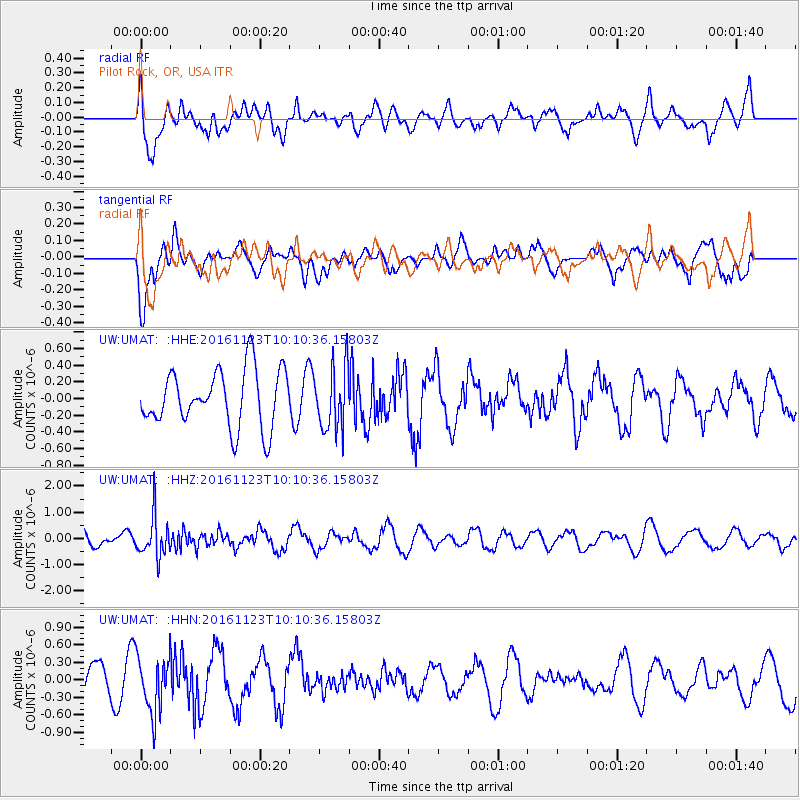
UMAT Pilot Rock, OR, USA - Earthquake Result Viewer
*The percent match for this event was below the threshold and hence no stack was calculated.
| Earthquake location: |
Bonin Islands, Japan Region |
| Earthquake latitude/longitude: |
27.2/140.0 |
| Earthquake time(UTC): |
2016/11/23 (328) 09:59:56 GMT |
| Earthquake Depth: |
477 km |
| Earthquake Magnitude: |
5.7 MB |
| Earthquake Catalog/Contributor: |
NEIC PDE/NEIC COMCAT |
|
| Network: |
UW Pacific Northwest Regional Seismic Network |
| Station: |
UMAT Pilot Rock, OR, USA |
| Lat/Lon: |
45.29 N/118.96 W |
| Elevation: |
1318 m |
|
| Distance: |
78.4 deg |
| Az: |
45.023 deg |
| Baz: |
296.761 deg |
| Ray Param: |
$rayparam |
*The percent match for this event was below the threshold and hence was not used in the summary stack. |
|
| Radial Match: |
64.26251 % |
| Radial Bump: |
400 |
| Transverse Match: |
37.61234 % |
| Transverse Bump: |
400 |
| SOD ConfigId: |
11737051 |
| Insert Time: |
2019-04-26 03:31:41.932 +0000 |
| GWidth: |
2.5 |
| Max Bumps: |
400 |
| Tol: |
0.001 |
|
Signal To Noise
| Channel | StoN | STA | LTA |
| UW:UMAT: :HHZ:20161123T10:10:36.15803Z | 3.2798698 | 7.8555826E-7 | 2.3950898E-7 |
| UW:UMAT: :HHN:20161123T10:10:36.15803Z | 1.6094812 | 4.802166E-7 | 2.9836733E-7 |
| UW:UMAT: :HHE:20161123T10:10:36.15803Z | 1.1227376 | 3.82134E-7 | 3.4035912E-7 |
| Arrivals |
| Ps | |
| PpPs | |
| PsPs/PpSs | |


