You are here: Home > Network List > BK - Berkeley Digital Seismograph Network Stations List
> Station WDC Whiskeytown, CA > Earthquake Result Viewer
WDC Whiskeytown, CA - Earthquake Result Viewer
| Earthquake location: |
Tonga Islands |
| Earthquake latitude/longitude: |
-20.8/-173.3 |
| Earthquake time(UTC): |
2008/06/26 (178) 21:19:15 GMT |
| Earthquake Depth: |
38 km |
| Earthquake Magnitude: |
6.0 MB, 5.8 MS, 6.2 MW, 6.1 MW |
| Earthquake Catalog/Contributor: |
WHDF/NEIC |
|
| Network: |
BK Berkeley Digital Seismograph Network |
| Station: |
WDC Whiskeytown, CA |
| Lat/Lon: |
40.58 N/122.54 W |
| Elevation: |
268 m |
|
| Distance: |
77.2 deg |
| Az: |
37.255 deg |
| Baz: |
228.054 deg |
| Ray Param: |
0.050445195 |
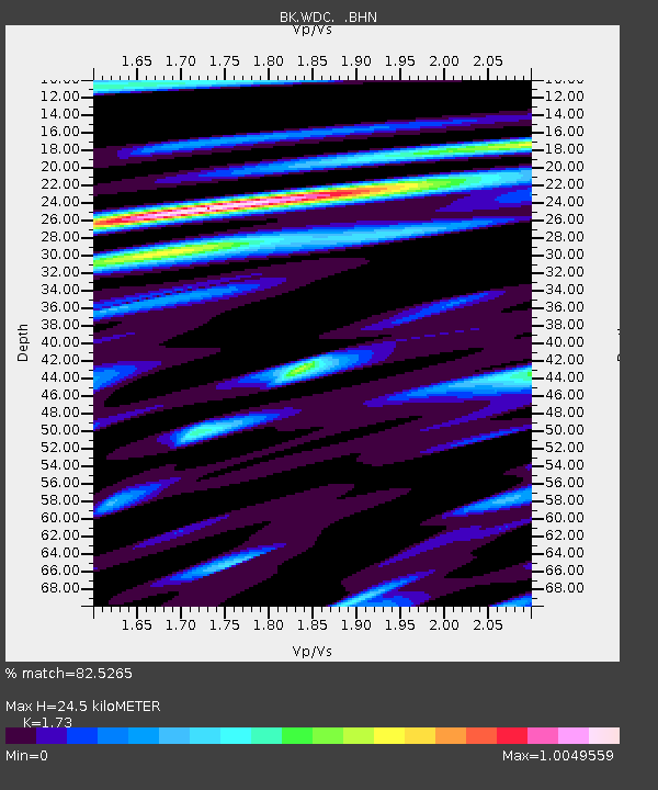
| Estimated Moho Depth: |
24.5 km |
| Estimated Crust Vp/Vs: |
1.73 |
| Assumed Crust Vp: |
6.566 km/s |
| Estimated Crust Vs: |
3.795 km/s |
| Estimated Crust Poisson's Ratio: |
0.25 |
|
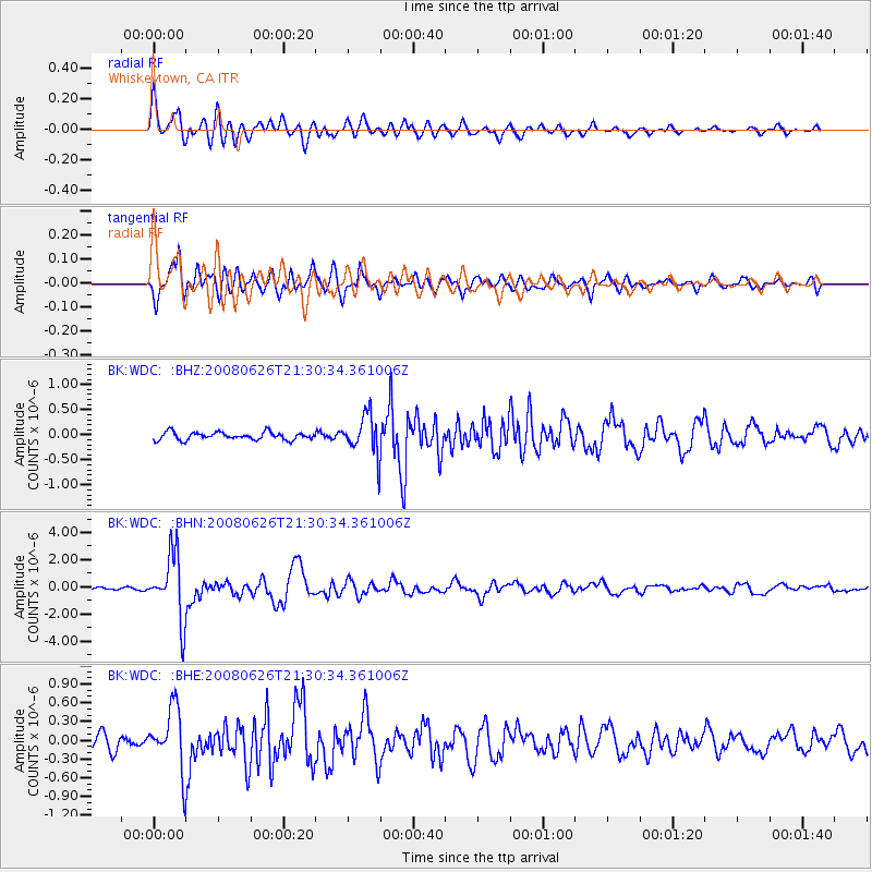
| Radial Match: |
82.5265 % |
| Radial Bump: |
400 |
| Transverse Match: |
85.18917 % |
| Transverse Bump: |
400 |
| SOD ConfigId: |
2504 |
| Insert Time: |
2010-03-05 19:56:54.552 +0000 |
| GWidth: |
2.5 |
| Max Bumps: |
400 |
| Tol: |
0.001 |
|
Signal To Noise
| Channel | StoN | STA | LTA |
| BK:WDC: :BHN:20080626T21:30:34.361006Z | 24.426716 | 2.3974753E-6 | 9.814972E-8 |
| BK:WDC: :BHE:20080626T21:30:34.361006Z | 3.2437458 | 4.902693E-7 | 1.5114296E-7 |
| BK:WDC: :BHZ:20080626T21:30:34.361006Z | 5.178857 | 3.9377935E-7 | 7.603596E-8 |
| Arrivals |
| Ps | 2.8 SECOND |
| PpPs | 9.9 SECOND |
| PsPs/PpSs | 13 SECOND |


