You are here: Home > Network List > TA - USArray Transportable Network (new EarthScope stations) Stations List
> Station J20K Nowitna River, AK, USA > Earthquake Result Viewer
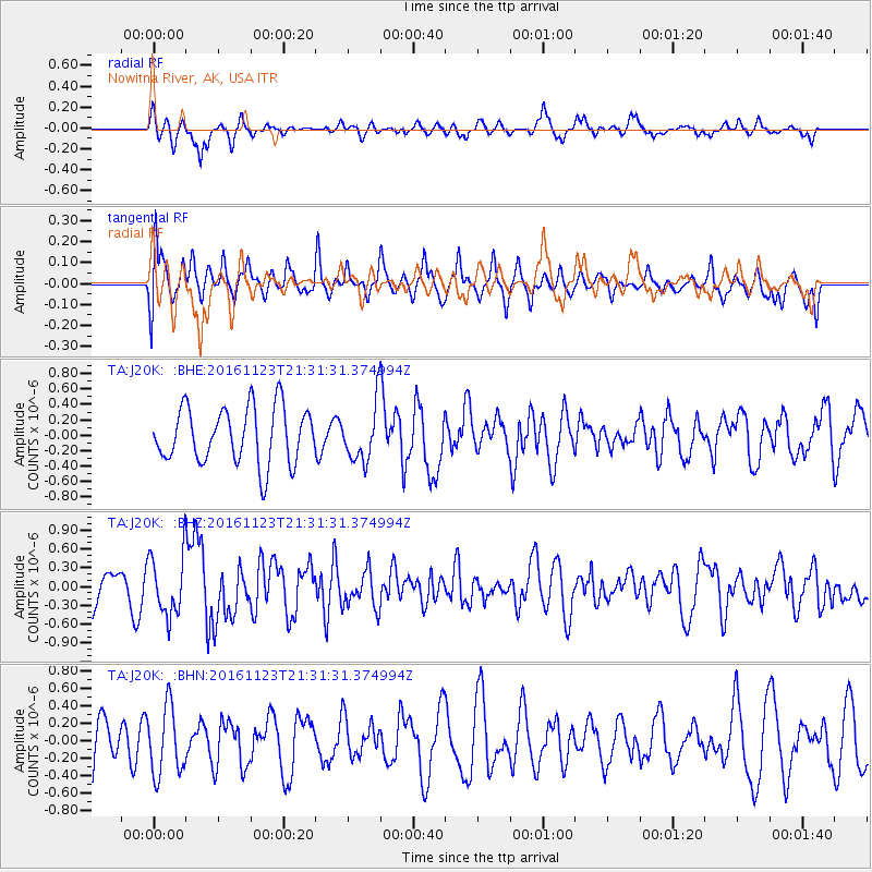
J20K Nowitna River, AK, USA - Earthquake Result Viewer
*The percent match for this event was below the threshold and hence no stack was calculated.
| Earthquake location: |
Near East Coast Of Honshu, Japan |
| Earthquake latitude/longitude: |
37.2/141.3 |
| Earthquake time(UTC): |
2016/11/23 (328) 21:23:37 GMT |
| Earthquake Depth: |
10 km |
| Earthquake Magnitude: |
5.6 MB |
| Earthquake Catalog/Contributor: |
NEIC PDE/NEIC COMCAT |
|
| Network: |
TA USArray Transportable Network (new EarthScope stations) |
| Station: |
J20K Nowitna River, AK, USA |
| Lat/Lon: |
64.18 N/154.15 W |
| Elevation: |
314 m |
|
| Distance: |
46.2 deg |
| Az: |
33.216 deg |
| Baz: |
266.485 deg |
| Ray Param: |
$rayparam |
*The percent match for this event was below the threshold and hence was not used in the summary stack. |
|
| Radial Match: |
51.92532 % |
| Radial Bump: |
385 |
| Transverse Match: |
43.821644 % |
| Transverse Bump: |
400 |
| SOD ConfigId: |
11737051 |
| Insert Time: |
2019-04-26 03:41:15.694 +0000 |
| GWidth: |
2.5 |
| Max Bumps: |
400 |
| Tol: |
0.001 |
|
Signal To Noise
| Channel | StoN | STA | LTA |
| TA:J20K: :BHZ:20161123T21:31:31.374994Z | 1.7484905 | 4.8609263E-7 | 2.7800704E-7 |
| TA:J20K: :BHN:20161123T21:31:31.374994Z | 1.0739465 | 3.9545677E-7 | 3.6822763E-7 |
| TA:J20K: :BHE:20161123T21:31:31.374994Z | 1.0968572 | 3.9561198E-7 | 3.6067775E-7 |
| Arrivals |
| Ps | |
| PpPs | |
| PsPs/PpSs | |


