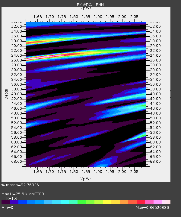
WDC Whiskeytown, CA - Earthquake Result Viewer

Earthquake location: Santa Cruz Islands Region
Earthquake latitude/longitude: -11.0/164.5
Earthquake time(UTC): 2008/07/19 (201) 09:27:01 GMT
Earthquake Depth: 11 km
Earthquake Magnitude: 6.1 MB, 6.4 MS, 6.6 MW, 6.6 MW
Earthquake Catalog/Contributor: WHDF/NEIC
Network: BK Berkeley Digital Seismograph Network
Station: WDC Whiskeytown, CA
Lat/Lon: 40.58 N/122.54 W
Elevation: 268 m
Distance: 84.5 deg
Az: 47.021 deg
Baz: 250.561 deg
Ray Param: 0.045432765
Estimated Moho Depth: 25.5 km
Estimated Crust Vp/Vs: 1.60
Assumed Crust Vp: 6.566 km/s
Estimated Crust Vs: 4.104 km/s
Estimated Crust Poisson's Ratio: 0.18
Radial Match: 92.76336 %
Radial Bump: 400
Transverse Match: 90.11532 %
Transverse Bump: 400
SOD ConfigId: 2658
Insert Time: 2010-03-05 19:57:12.435 +0000
GWidth: 2.5
Max Bumps: 400
Tol: 0.001

Signal To Noise

ChannelStoNSTALTA
BK:WDC: :BHN:20080719T09:39:02.798013Z32.469382.343165E-67.2165385E-8
BK:WDC: :BHE:20080719T09:39:02.798013Z2.50274523.2722096E-71.3074481E-7
BK:WDC: :BHZ:20080719T09:39:02.798013Z4.02063473.1225417E-77.7662904E-8
Arrivals
Ps2.4 SECOND
PpPs9.8 SECOND
PsPs/PpSs12 SECOND