You are here: Home > Network List > TA - USArray Transportable Network (new EarthScope stations) Stations List
> Station T25A Trinidad, CO, USA > Earthquake Result Viewer
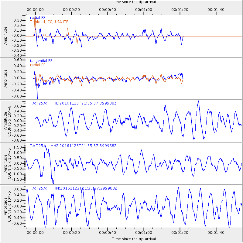
T25A Trinidad, CO, USA - Earthquake Result Viewer
*The percent match for this event was below the threshold and hence no stack was calculated.
| Earthquake location: |
Near East Coast Of Honshu, Japan |
| Earthquake latitude/longitude: |
37.2/141.3 |
| Earthquake time(UTC): |
2016/11/23 (328) 21:23:37 GMT |
| Earthquake Depth: |
10 km |
| Earthquake Magnitude: |
5.6 MB |
| Earthquake Catalog/Contributor: |
NEIC PDE/NEIC COMCAT |
|
| Network: |
TA USArray Transportable Network (new EarthScope stations) |
| Station: |
T25A Trinidad, CO, USA |
| Lat/Lon: |
37.14 N/104.41 W |
| Elevation: |
2017 m |
|
| Distance: |
84.3 deg |
| Az: |
47.057 deg |
| Baz: |
313.029 deg |
| Ray Param: |
$rayparam |
*The percent match for this event was below the threshold and hence was not used in the summary stack. |
|
| Radial Match: |
69.10882 % |
| Radial Bump: |
400 |
| Transverse Match: |
78.298355 % |
| Transverse Bump: |
400 |
| SOD ConfigId: |
11737051 |
| Insert Time: |
2019-04-26 03:41:38.064 +0000 |
| GWidth: |
2.5 |
| Max Bumps: |
400 |
| Tol: |
0.001 |
|
Signal To Noise
| Channel | StoN | STA | LTA |
| TA:T25A: :HHZ:20161123T21:35:37.399988Z | 2.3999674 | 6.32866E-7 | 2.6369773E-7 |
| TA:T25A: :HHN:20161123T21:35:37.399988Z | 0.69116807 | 2.7126367E-7 | 3.9247132E-7 |
| TA:T25A: :HHE:20161123T21:35:37.399988Z | 0.8050069 | 2.1645434E-7 | 2.688851E-7 |
| Arrivals |
| Ps | |
| PpPs | |
| PsPs/PpSs | |


