You are here: Home > Network List > AK - Alaska Regional Network Stations List
> Station CUT Chulitna, AK, USA > Earthquake Result Viewer
CUT Chulitna, AK, USA - Earthquake Result Viewer
| Earthquake location: |
Off Coast Of Central America |
| Earthquake latitude/longitude: |
12.0/-88.8 |
| Earthquake time(UTC): |
2016/11/24 (329) 18:43:48 GMT |
| Earthquake Depth: |
10 km |
| Earthquake Magnitude: |
7.0 MWW, 6.7 MWB, 7.2 MI |
| Earthquake Catalog/Contributor: |
NEIC PDE/NEIC COMCAT |
|
| Network: |
AK Alaska Regional Network |
| Station: |
CUT Chulitna, AK, USA |
| Lat/Lon: |
62.41 N/150.26 W |
| Elevation: |
574 m |
|
| Distance: |
66.4 deg |
| Az: |
333.498 deg |
| Baz: |
110.324 deg |
| Ray Param: |
0.057632506 |
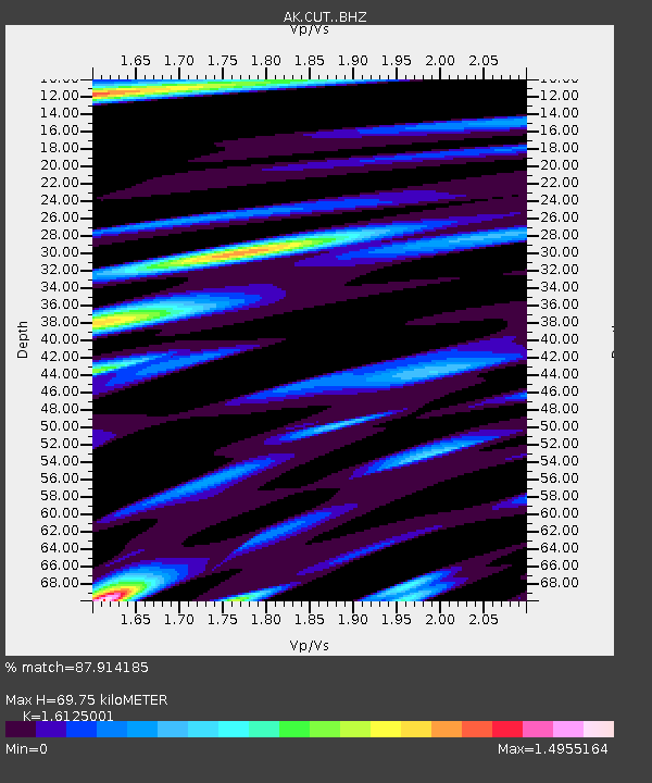
| Estimated Moho Depth: |
69.75 km |
| Estimated Crust Vp/Vs: |
1.61 |
| Assumed Crust Vp: |
6.438 km/s |
| Estimated Crust Vs: |
3.993 km/s |
| Estimated Crust Poisson's Ratio: |
0.19 |
|
| Radial Match: |
87.914185 % |
| Radial Bump: |
400 |
| Transverse Match: |
65.41554 % |
| Transverse Bump: |
400 |
| SOD ConfigId: |
11737051 |
| Insert Time: |
2019-04-26 03:44:22.944 +0000 |
| GWidth: |
2.5 |
| Max Bumps: |
400 |
| Tol: |
0.001 |
|

Signal To Noise
| Channel | StoN | STA | LTA |
| AK:CUT: :BHZ:20161124T18:54:06.759993Z | 41.71376 | 1.0047364E-5 | 2.408645E-7 |
| AK:CUT: :BHN:20161124T18:54:06.759993Z | 6.655644 | 3.6753659E-6 | 5.522179E-7 |
| AK:CUT: :BHE:20161124T18:54:06.759993Z | 13.556157 | 5.419092E-6 | 3.9975134E-7 |
| Arrivals |
| Ps | 6.9 SECOND |
| PpPs | 27 SECOND |
| PsPs/PpSs | 34 SECOND |


