You are here: Home > Network List > BK - Berkeley Digital Seismograph Network Stations List
> Station WDC Whiskeytown, CA > Earthquake Result Viewer
WDC Whiskeytown, CA - Earthquake Result Viewer
| Earthquake location: |
Central Mid-Atlantic Ridge |
| Earthquake latitude/longitude: |
8.0/-39.2 |
| Earthquake time(UTC): |
2007/08/20 (232) 22:42:29 GMT |
| Earthquake Depth: |
10 km |
| Earthquake Magnitude: |
6.3 MB, 6.4 MS, 6.5 MW |
| Earthquake Catalog/Contributor: |
WHDF/NEIC |
|
| Network: |
BK Berkeley Digital Seismograph Network |
| Station: |
WDC Whiskeytown, CA |
| Lat/Lon: |
40.58 N/122.54 W |
| Elevation: |
268 m |
|
| Distance: |
79.7 deg |
| Az: |
309.76 deg |
| Baz: |
88.203 deg |
| Ray Param: |
0.04875334 |
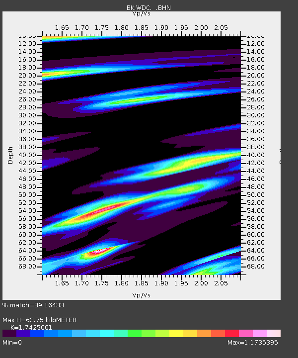
| Estimated Moho Depth: |
63.75 km |
| Estimated Crust Vp/Vs: |
1.74 |
| Assumed Crust Vp: |
6.566 km/s |
| Estimated Crust Vs: |
3.768 km/s |
| Estimated Crust Poisson's Ratio: |
0.25 |
|
| Radial Match: |
89.16433 % |
| Radial Bump: |
400 |
| Transverse Match: |
69.19319 % |
| Transverse Bump: |
400 |
| SOD ConfigId: |
2564 |
| Insert Time: |
2010-03-05 19:57:35.588 +0000 |
| GWidth: |
2.5 |
| Max Bumps: |
400 |
| Tol: |
0.001 |
|
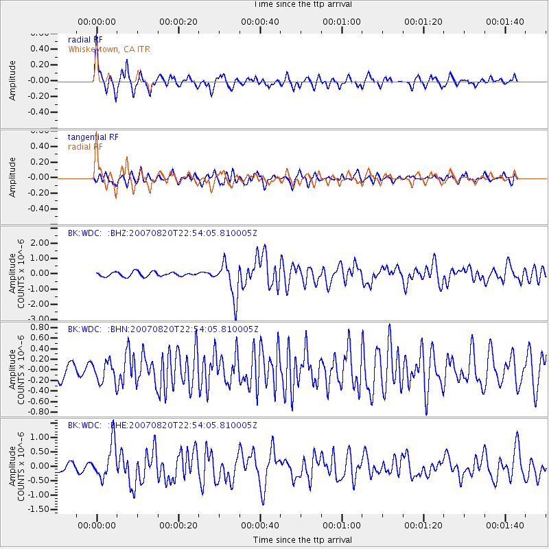
Signal To Noise
| Channel | StoN | STA | LTA |
| BK:WDC: :BHN:20070820T22:54:05.810005Z | 1.5869082 | 2.0036437E-7 | 1.2626084E-7 |
| BK:WDC: :BHE:20070820T22:54:05.810005Z | 5.001786 | 6.2575356E-7 | 1.2510603E-7 |
| BK:WDC: :BHZ:20070820T22:54:05.810005Z | 8.436513 | 1.1867959E-6 | 1.4067375E-7 |
| Arrivals |
| Ps | 7.4 SECOND |
| PpPs | 26 SECOND |
| PsPs/PpSs | 33 SECOND |


