You are here: Home > Network List > AK - Alaska Regional Network Stations List
> Station PAX Paxson > Earthquake Result Viewer
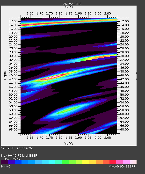
PAX Paxson - Earthquake Result Viewer
| Earthquake location: |
Off Coast Of Central America |
| Earthquake latitude/longitude: |
12.0/-88.8 |
| Earthquake time(UTC): |
2016/11/24 (329) 18:43:48 GMT |
| Earthquake Depth: |
10 km |
| Earthquake Magnitude: |
7.0 MWW, 6.7 MWB, 7.2 MI |
| Earthquake Catalog/Contributor: |
NEIC PDE/NEIC COMCAT |
|
| Network: |
AK Alaska Regional Network |
| Station: |
PAX Paxson |
| Lat/Lon: |
62.97 N/145.47 W |
| Elevation: |
1130 m |
|
| Distance: |
64.6 deg |
| Az: |
335.013 deg |
| Baz: |
115.207 deg |
| Ray Param: |
0.058822423 |
| Estimated Moho Depth: |
40.75 km |
| Estimated Crust Vp/Vs: |
1.76 |
| Assumed Crust Vp: |
6.566 km/s |
| Estimated Crust Vs: |
3.736 km/s |
| Estimated Crust Poisson's Ratio: |
0.26 |
|
| Radial Match: |
95.639626 % |
| Radial Bump: |
263 |
| Transverse Match: |
82.55512 % |
| Transverse Bump: |
400 |
| SOD ConfigId: |
11737051 |
| Insert Time: |
2019-04-26 03:44:34.427 +0000 |
| GWidth: |
2.5 |
| Max Bumps: |
400 |
| Tol: |
0.001 |
|

Signal To Noise
| Channel | StoN | STA | LTA |
| AK:PAX: :BHZ:20161124T18:53:55.027998Z | 39.815502 | 6.7978035E-6 | 1.7073258E-7 |
| AK:PAX: :BHN:20161124T18:53:55.027998Z | 13.863281 | 1.7671043E-6 | 1.2746654E-7 |
| AK:PAX: :BHE:20161124T18:53:55.027998Z | 13.555771 | 2.778184E-6 | 2.0494474E-7 |
| Arrivals |
| Ps | 4.9 SECOND |
| PpPs | 16 SECOND |
| PsPs/PpSs | 21 SECOND |


