You are here: Home > Network List > IU - Global Seismograph Network (GSN - IRIS/USGS) Stations List
> Station HKT Hockley, Texas > Earthquake Result Viewer
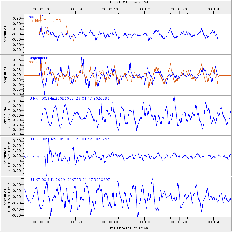
HKT Hockley, Texas - Earthquake Result Viewer
*The percent match for this event was below the threshold and hence no stack was calculated.
| Earthquake location: |
Samoa Islands Region |
| Earthquake latitude/longitude: |
-15.4/-172.3 |
| Earthquake time(UTC): |
2009/10/19 (292) 22:49:38 GMT |
| Earthquake Depth: |
18 km |
| Earthquake Magnitude: |
6.2 MB, 5.7 MS, 6.0 MW, 5.9 MW |
| Earthquake Catalog/Contributor: |
WHDF/NEIC |
|
| Network: |
IU Global Seismograph Network (GSN - IRIS/USGS) |
| Station: |
HKT Hockley, Texas |
| Lat/Lon: |
29.96 N/95.84 W |
| Elevation: |
-413.0 m |
|
| Distance: |
86.2 deg |
| Az: |
57.714 deg |
| Baz: |
250.02 deg |
| Ray Param: |
$rayparam |
*The percent match for this event was below the threshold and hence was not used in the summary stack. |
|
| Radial Match: |
56.568356 % |
| Radial Bump: |
400 |
| Transverse Match: |
72.25848 % |
| Transverse Bump: |
373 |
| SOD ConfigId: |
1 |
| Insert Time: |
2010-02-19 00:52:08.836 +0000 |
| GWidth: |
2.5 |
| Max Bumps: |
400 |
| Tol: |
0.001 |
|
Signal To Noise
| Channel | StoN | STA | LTA |
| IU:HKT:00:BHZ:20091019T23:01:47.302029Z | 10.571926 | 1.7154863E-6 | 1.6226808E-7 |
| IU:HKT:00:BHN:20091019T23:01:47.302029Z | 1.1628393 | 2.8873933E-7 | 2.4830544E-7 |
| IU:HKT:00:BHE:20091019T23:01:47.302029Z | 1.2594147 | 3.2454003E-7 | 2.5769117E-7 |
| Arrivals |
| Ps | |
| PpPs | |
| PsPs/PpSs | |


