You are here: Home > Network List > C1 - Red Sismologica Nacional Stations List
> Station AF01 SAN PEDRO DE ATACAMA > Earthquake Result Viewer
AF01 SAN PEDRO DE ATACAMA - Earthquake Result Viewer
| Earthquake location: |
Off Coast Of Central America |
| Earthquake latitude/longitude: |
12.0/-88.8 |
| Earthquake time(UTC): |
2016/11/24 (329) 18:43:48 GMT |
| Earthquake Depth: |
10 km |
| Earthquake Magnitude: |
7.0 MWW, 6.7 MWB, 7.2 MI |
| Earthquake Catalog/Contributor: |
NEIC PDE/NEIC COMCAT |
|
| Network: |
C1 Red Sismologica Nacional |
| Station: |
AF01 SAN PEDRO DE ATACAMA |
| Lat/Lon: |
22.95 S/68.18 W |
| Elevation: |
2372 m |
|
| Distance: |
40.2 deg |
| Az: |
149.725 deg |
| Baz: |
327.641 deg |
| Ray Param: |
0.07454829 |
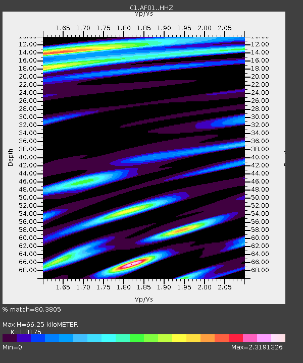
| Estimated Moho Depth: |
66.25 km |
| Estimated Crust Vp/Vs: |
1.82 |
| Assumed Crust Vp: |
6.475 km/s |
| Estimated Crust Vs: |
3.563 km/s |
| Estimated Crust Poisson's Ratio: |
0.28 |
|
| Radial Match: |
80.3805 % |
| Radial Bump: |
400 |
| Transverse Match: |
60.619225 % |
| Transverse Bump: |
400 |
| SOD ConfigId: |
11737051 |
| Insert Time: |
2019-04-26 03:46:05.020 +0000 |
| GWidth: |
2.5 |
| Max Bumps: |
400 |
| Tol: |
0.001 |
|

Signal To Noise
| Channel | StoN | STA | LTA |
| C1:AF01: :HHZ:20161124T18:50:54.099989Z | 31.80444 | 6.3924E-6 | 2.009908E-7 |
| C1:AF01: :HHN:20161124T18:50:54.099989Z | 4.06875 | 3.444489E-6 | 8.4657177E-7 |
| C1:AF01: :HHE:20161124T18:50:54.099989Z | 4.43591 | 1.8341892E-6 | 4.1348656E-7 |
| Arrivals |
| Ps | 9.0 SECOND |
| PpPs | 27 SECOND |
| PsPs/PpSs | 36 SECOND |


