You are here: Home > Network List > C1 - Red Sismologica Nacional Stations List
> Station MT02 Curacavi > Earthquake Result Viewer
MT02 Curacavi - Earthquake Result Viewer
| Earthquake location: |
Off Coast Of Central America |
| Earthquake latitude/longitude: |
12.0/-88.8 |
| Earthquake time(UTC): |
2016/11/24 (329) 18:43:48 GMT |
| Earthquake Depth: |
10 km |
| Earthquake Magnitude: |
7.0 MWW, 6.7 MWB, 7.2 MI |
| Earthquake Catalog/Contributor: |
NEIC PDE/NEIC COMCAT |
|
| Network: |
C1 Red Sismologica Nacional |
| Station: |
MT02 Curacavi |
| Lat/Lon: |
33.26 S/71.14 W |
| Elevation: |
338 m |
|
| Distance: |
48.0 deg |
| Az: |
159.965 deg |
| Baz: |
336.415 deg |
| Ray Param: |
0.0696165 |
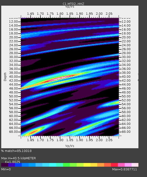
| Estimated Moho Depth: |
40.5 km |
| Estimated Crust Vp/Vs: |
1.80 |
| Assumed Crust Vp: |
6.481 km/s |
| Estimated Crust Vs: |
3.595 km/s |
| Estimated Crust Poisson's Ratio: |
0.28 |
|
| Radial Match: |
85.10018 % |
| Radial Bump: |
400 |
| Transverse Match: |
58.15205 % |
| Transverse Bump: |
400 |
| SOD ConfigId: |
11737051 |
| Insert Time: |
2019-04-26 03:46:26.314 +0000 |
| GWidth: |
2.5 |
| Max Bumps: |
400 |
| Tol: |
0.001 |
|

Signal To Noise
| Channel | StoN | STA | LTA |
| C1:MT02: :HHZ:20161124T18:51:57.080Z | 31.966915 | 9.0195235E-6 | 2.8215183E-7 |
| C1:MT02: :HHN:20161124T18:51:57.080Z | 21.037659 | 4.5663787E-6 | 2.1705736E-7 |
| C1:MT02: :HHE:20161124T18:51:57.080Z | 2.06886 | 2.5766724E-6 | 1.2454551E-6 |
| Arrivals |
| Ps | 5.3 SECOND |
| PpPs | 16 SECOND |
| PsPs/PpSs | 22 SECOND |


