You are here: Home > Network List > CI - Caltech Regional Seismic Network Stations List
> Station FMP Fort MacArthur Park, Pt. Fermin San Pedro, CA, USA > Earthquake Result Viewer
FMP Fort MacArthur Park, Pt. Fermin San Pedro, CA, USA - Earthquake Result Viewer
| Earthquake location: |
Off Coast Of Central America |
| Earthquake latitude/longitude: |
12.0/-88.8 |
| Earthquake time(UTC): |
2016/11/24 (329) 18:43:48 GMT |
| Earthquake Depth: |
10 km |
| Earthquake Magnitude: |
7.0 MWW, 6.7 MWB, 7.2 MI |
| Earthquake Catalog/Contributor: |
NEIC PDE/NEIC COMCAT |
|
| Network: |
CI Caltech Regional Seismic Network |
| Station: |
FMP Fort MacArthur Park, Pt. Fermin San Pedro, CA, USA |
| Lat/Lon: |
33.71 N/118.29 W |
| Elevation: |
89 m |
|
| Distance: |
34.5 deg |
| Az: |
313.659 deg |
| Baz: |
121.861 deg |
| Ray Param: |
0.07770111 |
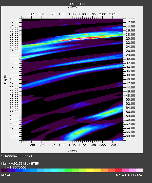
| Estimated Moho Depth: |
20.25 km |
| Estimated Crust Vp/Vs: |
1.87 |
| Assumed Crust Vp: |
6.048 km/s |
| Estimated Crust Vs: |
3.239 km/s |
| Estimated Crust Poisson's Ratio: |
0.30 |
|
| Radial Match: |
89.95671 % |
| Radial Bump: |
281 |
| Transverse Match: |
80.02988 % |
| Transverse Bump: |
400 |
| SOD ConfigId: |
11737051 |
| Insert Time: |
2019-04-26 03:47:13.903 +0000 |
| GWidth: |
2.5 |
| Max Bumps: |
400 |
| Tol: |
0.001 |
|

Signal To Noise
| Channel | StoN | STA | LTA |
| CI:FMP: :HHZ:20161124T18:50:06.288008Z | 22.88429 | 1.1514966E-5 | 5.0318215E-7 |
| CI:FMP: :HHN:20161124T18:50:06.288008Z | 10.115014 | 7.165943E-6 | 7.084462E-7 |
| CI:FMP: :HHE:20161124T18:50:06.288008Z | 6.191335 | 4.663236E-6 | 7.531874E-7 |
| Arrivals |
| Ps | 3.1 SECOND |
| PpPs | 9.0 SECOND |
| PsPs/PpSs | 12 SECOND |


