You are here: Home > Network List > CI - Caltech Regional Seismic Network Stations List
> Station GLA Glamis, Glamis, CA, USA > Earthquake Result Viewer
GLA Glamis, Glamis, CA, USA - Earthquake Result Viewer
| Earthquake location: |
Off Coast Of Central America |
| Earthquake latitude/longitude: |
12.0/-88.8 |
| Earthquake time(UTC): |
2016/11/24 (329) 18:43:48 GMT |
| Earthquake Depth: |
10 km |
| Earthquake Magnitude: |
7.0 MWW, 6.7 MWB, 7.2 MI |
| Earthquake Catalog/Contributor: |
NEIC PDE/NEIC COMCAT |
|
| Network: |
CI Caltech Regional Seismic Network |
| Station: |
GLA Glamis, Glamis, CA, USA |
| Lat/Lon: |
33.05 N/114.83 W |
| Elevation: |
610 m |
|
| Distance: |
31.7 deg |
| Az: |
315.593 deg |
| Baz: |
125.38 deg |
| Ray Param: |
0.078950346 |
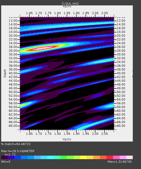
| Estimated Moho Depth: |
26.5 km |
| Estimated Crust Vp/Vs: |
1.72 |
| Assumed Crust Vp: |
6.155 km/s |
| Estimated Crust Vs: |
3.578 km/s |
| Estimated Crust Poisson's Ratio: |
0.24 |
|
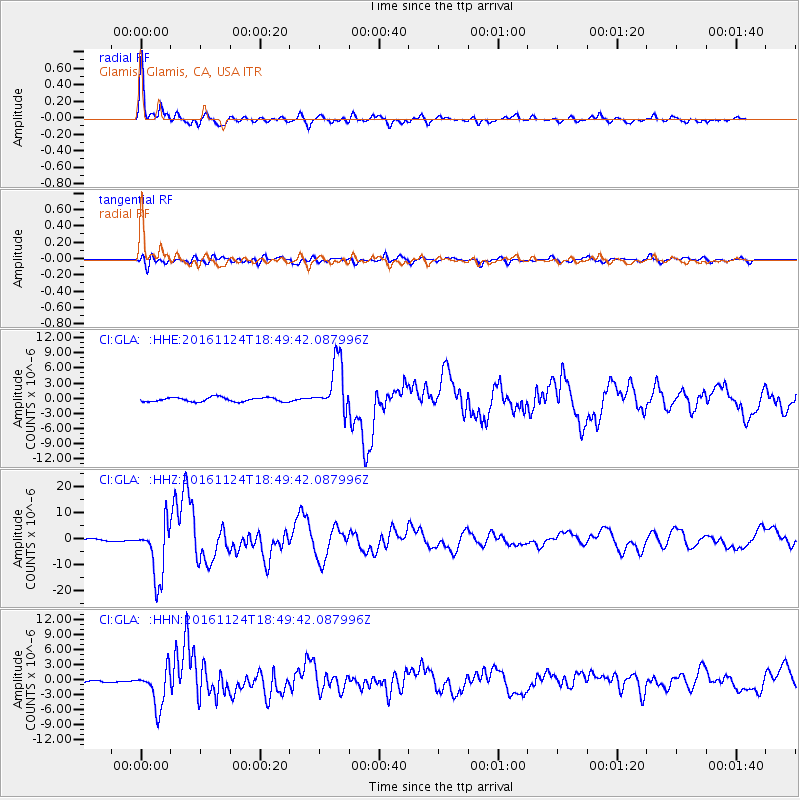
| Radial Match: |
94.46723 % |
| Radial Bump: |
400 |
| Transverse Match: |
84.439285 % |
| Transverse Bump: |
400 |
| SOD ConfigId: |
11737051 |
| Insert Time: |
2019-04-26 03:47:15.188 +0000 |
| GWidth: |
2.5 |
| Max Bumps: |
400 |
| Tol: |
0.001 |
|
Signal To Noise
| Channel | StoN | STA | LTA |
| CI:GLA: :HHZ:20161124T18:49:42.087996Z | 27.120718 | 1.0835189E-5 | 3.9951706E-7 |
| CI:GLA: :HHN:20161124T18:49:42.087996Z | 14.037724 | 3.883081E-6 | 2.7661756E-7 |
| CI:GLA: :HHE:20161124T18:49:42.087996Z | 12.492669 | 5.140368E-6 | 4.1147075E-7 |
| Arrivals |
| Ps | 3.3 SECOND |
| PpPs | 11 SECOND |
| PsPs/PpSs | 14 SECOND |


