You are here: Home > Network List > CI - Caltech Regional Seismic Network Stations List
> Station GRA Grapevine Ranger Station, Death Valley, CA, USA > Earthquake Result Viewer
GRA Grapevine Ranger Station, Death Valley, CA, USA - Earthquake Result Viewer
| Earthquake location: |
Off Coast Of Central America |
| Earthquake latitude/longitude: |
12.0/-88.8 |
| Earthquake time(UTC): |
2016/11/24 (329) 18:43:48 GMT |
| Earthquake Depth: |
10 km |
| Earthquake Magnitude: |
7.0 MWW, 6.7 MWB, 7.2 MI |
| Earthquake Catalog/Contributor: |
NEIC PDE/NEIC COMCAT |
|
| Network: |
CI Caltech Regional Seismic Network |
| Station: |
GRA Grapevine Ranger Station, Death Valley, CA, USA |
| Lat/Lon: |
37.00 N/117.37 W |
| Elevation: |
689 m |
|
| Distance: |
35.7 deg |
| Az: |
319.104 deg |
| Baz: |
126.85 deg |
| Ray Param: |
0.07706046 |
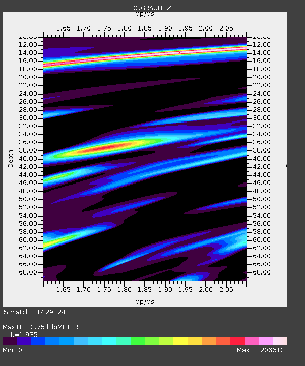
| Estimated Moho Depth: |
13.75 km |
| Estimated Crust Vp/Vs: |
1.93 |
| Assumed Crust Vp: |
6.279 km/s |
| Estimated Crust Vs: |
3.245 km/s |
| Estimated Crust Poisson's Ratio: |
0.32 |
|
| Radial Match: |
87.29124 % |
| Radial Bump: |
400 |
| Transverse Match: |
78.004295 % |
| Transverse Bump: |
400 |
| SOD ConfigId: |
11737051 |
| Insert Time: |
2019-04-26 03:47:16.424 +0000 |
| GWidth: |
2.5 |
| Max Bumps: |
400 |
| Tol: |
0.001 |
|

Signal To Noise
| Channel | StoN | STA | LTA |
| CI:GRA: :HHZ:20161124T18:50:16.807997Z | 77.298294 | 1.2988086E-5 | 1.6802552E-7 |
| CI:GRA: :HHN:20161124T18:50:16.807997Z | 6.7575526 | 4.5780225E-6 | 6.7746754E-7 |
| CI:GRA: :HHE:20161124T18:50:16.807997Z | 12.762611 | 5.153718E-6 | 4.0381374E-7 |
| Arrivals |
| Ps | 2.2 SECOND |
| PpPs | 6.0 SECOND |
| PsPs/PpSs | 8.2 SECOND |


