You are here: Home > Network List > CI - Caltech Regional Seismic Network Stations List
> Station SWS Sam W. Stewart, Westmorland, CA, USA > Earthquake Result Viewer
SWS Sam W. Stewart, Westmorland, CA, USA - Earthquake Result Viewer
| Earthquake location: |
Off Coast Of Central America |
| Earthquake latitude/longitude: |
12.0/-88.8 |
| Earthquake time(UTC): |
2016/11/24 (329) 18:43:48 GMT |
| Earthquake Depth: |
10 km |
| Earthquake Magnitude: |
7.0 MWW, 6.7 MWB, 7.2 MI |
| Earthquake Catalog/Contributor: |
NEIC PDE/NEIC COMCAT |
|
| Network: |
CI Caltech Regional Seismic Network |
| Station: |
SWS Sam W. Stewart, Westmorland, CA, USA |
| Lat/Lon: |
32.94 N/115.80 W |
| Elevation: |
140 m |
|
| Distance: |
32.3 deg |
| Az: |
314.549 deg |
| Baz: |
123.97 deg |
| Ray Param: |
0.078692324 |
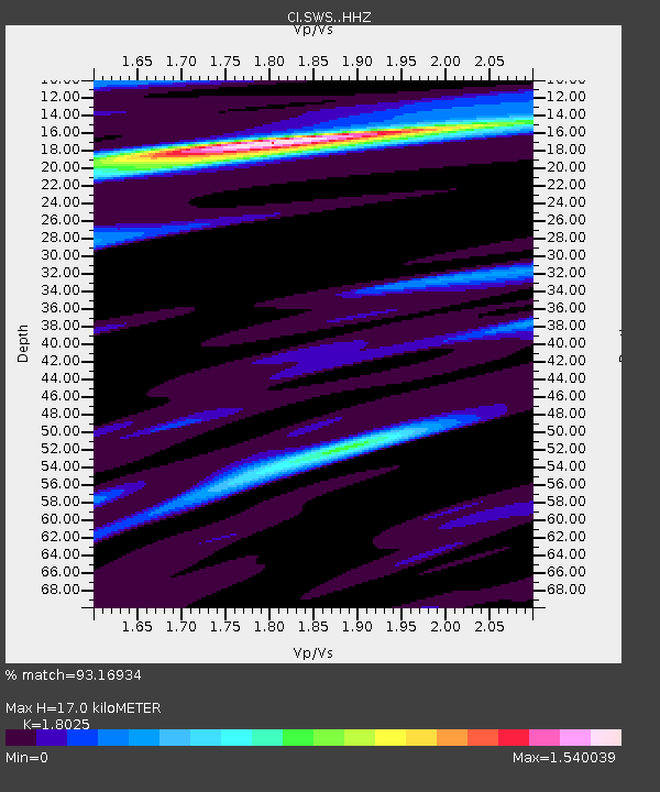
| Estimated Moho Depth: |
17.0 km |
| Estimated Crust Vp/Vs: |
1.80 |
| Assumed Crust Vp: |
6.155 km/s |
| Estimated Crust Vs: |
3.414 km/s |
| Estimated Crust Poisson's Ratio: |
0.28 |
|
| Radial Match: |
93.16934 % |
| Radial Bump: |
400 |
| Transverse Match: |
87.02896 % |
| Transverse Bump: |
400 |
| SOD ConfigId: |
11737051 |
| Insert Time: |
2019-04-26 03:47:46.715 +0000 |
| GWidth: |
2.5 |
| Max Bumps: |
400 |
| Tol: |
0.001 |
|

Signal To Noise
| Channel | StoN | STA | LTA |
| CI:SWS: :HHZ:20161124T18:49:47.448011Z | 34.11662 | 1.1385165E-5 | 3.3371316E-7 |
| CI:SWS: :HHN:20161124T18:49:47.448011Z | 9.620771 | 4.422727E-6 | 4.597061E-7 |
| CI:SWS: :HHE:20161124T18:49:47.448011Z | 8.517243 | 5.2548116E-6 | 6.169616E-7 |
| Arrivals |
| Ps | 2.4 SECOND |
| PpPs | 7.2 SECOND |
| PsPs/PpSs | 9.6 SECOND |


