You are here: Home > Network List > BK - Berkeley Digital Seismograph Network Stations List
> Station WDC Whiskeytown, CA > Earthquake Result Viewer
WDC Whiskeytown, CA - Earthquake Result Viewer
| Earthquake location: |
Kuril Islands |
| Earthquake latitude/longitude: |
46.3/153.3 |
| Earthquake time(UTC): |
2006/10/13 (286) 13:47:39 GMT |
| Earthquake Depth: |
8.0 km |
| Earthquake Magnitude: |
5.5 MB, 5.8 MS, 6.3 MW, 5.8 MW |
| Earthquake Catalog/Contributor: |
WHDF/NEIC |
|
| Network: |
BK Berkeley Digital Seismograph Network |
| Station: |
WDC Whiskeytown, CA |
| Lat/Lon: |
40.58 N/122.54 W |
| Elevation: |
268 m |
|
| Distance: |
58.7 deg |
| Az: |
62.525 deg |
| Baz: |
306.07 deg |
| Ray Param: |
0.06270736 |
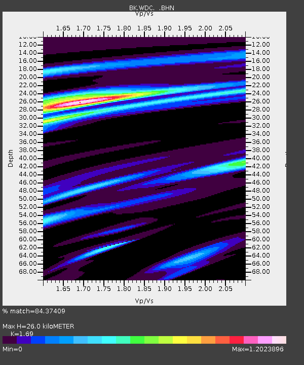
| Estimated Moho Depth: |
26.0 km |
| Estimated Crust Vp/Vs: |
1.69 |
| Assumed Crust Vp: |
6.566 km/s |
| Estimated Crust Vs: |
3.885 km/s |
| Estimated Crust Poisson's Ratio: |
0.23 |
|
| Radial Match: |
84.37409 % |
| Radial Bump: |
400 |
| Transverse Match: |
72.592804 % |
| Transverse Bump: |
400 |
| SOD ConfigId: |
2665 |
| Insert Time: |
2010-03-05 19:58:52.950 +0000 |
| GWidth: |
2.5 |
| Max Bumps: |
400 |
| Tol: |
0.001 |
|
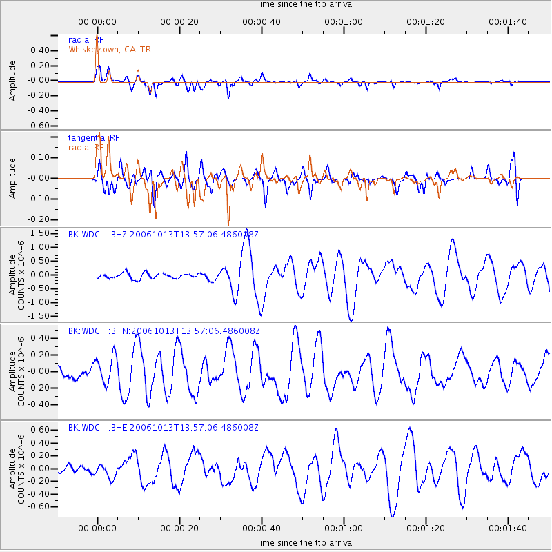
Signal To Noise
| Channel | StoN | STA | LTA |
| BK:WDC: :BHN:20061013T13:57:06.486008Z | 1.5591971 | 1.6377687E-7 | 1.0503924E-7 |
| BK:WDC: :BHE:20061013T13:57:06.486008Z | 0.74516314 | 1.0414978E-7 | 1.3976775E-7 |
| BK:WDC: :BHZ:20061013T13:57:06.486008Z | 4.961289 | 4.700595E-7 | 9.474544E-8 |
| Arrivals |
| Ps | 2.9 SECOND |
| PpPs | 10 SECOND |
| PsPs/PpSs | 13 SECOND |


