You are here: Home > Network List > CN - Canadian National Seismograph Network Stations List
> Station MALO Mcalpine Lake, ON, CA > Earthquake Result Viewer
MALO Mcalpine Lake, ON, CA - Earthquake Result Viewer
| Earthquake location: |
Off Coast Of Central America |
| Earthquake latitude/longitude: |
12.0/-88.8 |
| Earthquake time(UTC): |
2016/11/24 (329) 18:43:48 GMT |
| Earthquake Depth: |
10 km |
| Earthquake Magnitude: |
7.0 MWW, 6.7 MWB, 7.2 MI |
| Earthquake Catalog/Contributor: |
NEIC PDE/NEIC COMCAT |
|
| Network: |
CN Canadian National Seismograph Network |
| Station: |
MALO Mcalpine Lake, ON, CA |
| Lat/Lon: |
50.02 N/79.76 W |
| Elevation: |
271 m |
|
| Distance: |
38.7 deg |
| Az: |
9.365 deg |
| Baz: |
194.293 deg |
| Ray Param: |
0.07541988 |
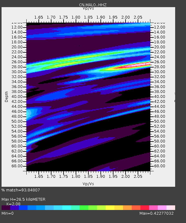
| Estimated Moho Depth: |
26.5 km |
| Estimated Crust Vp/Vs: |
2.08 |
| Assumed Crust Vp: |
6.459 km/s |
| Estimated Crust Vs: |
3.106 km/s |
| Estimated Crust Poisson's Ratio: |
0.35 |
|
| Radial Match: |
93.84807 % |
| Radial Bump: |
182 |
| Transverse Match: |
90.67087 % |
| Transverse Bump: |
278 |
| SOD ConfigId: |
11737051 |
| Insert Time: |
2019-04-26 03:48:22.038 +0000 |
| GWidth: |
2.5 |
| Max Bumps: |
400 |
| Tol: |
0.001 |
|

Signal To Noise
| Channel | StoN | STA | LTA |
| CN:MALO: :HHZ:20161124T18:50:41.750013Z | 5.913695 | 6.217851E-6 | 1.0514325E-6 |
| CN:MALO: :HHN:20161124T18:50:41.750013Z | 5.8762 | 3.7946218E-6 | 6.4576113E-7 |
| CN:MALO: :HHE:20161124T18:50:41.750013Z | 0.9454015 | 8.131493E-7 | 8.6011E-7 |
| Arrivals |
| Ps | 4.7 SECOND |
| PpPs | 12 SECOND |
| PsPs/PpSs | 17 SECOND |


