You are here: Home > Network List > GB - Great Britain Seismograph Network Stations List
> Station INVG INVERGELDIE , ENGLAND > Earthquake Result Viewer
INVG INVERGELDIE , ENGLAND - Earthquake Result Viewer
| Earthquake location: |
Off Coast Of Central America |
| Earthquake latitude/longitude: |
12.0/-88.8 |
| Earthquake time(UTC): |
2016/11/24 (329) 18:43:48 GMT |
| Earthquake Depth: |
10 km |
| Earthquake Magnitude: |
7.0 MWW, 6.7 MWB, 7.2 MI |
| Earthquake Catalog/Contributor: |
NEIC PDE/NEIC COMCAT |
|
| Network: |
GB Great Britain Seismograph Network |
| Station: |
INVG INVERGELDIE , ENGLAND |
| Lat/Lon: |
56.43 N/4.04 W |
| Elevation: |
279 m |
|
| Distance: |
77.3 deg |
| Az: |
34.559 deg |
| Baz: |
272.381 deg |
| Ray Param: |
0.05044346 |
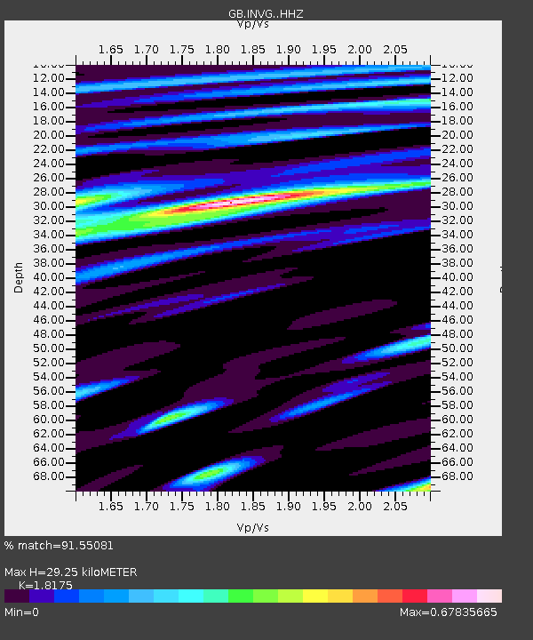
| Estimated Moho Depth: |
29.25 km |
| Estimated Crust Vp/Vs: |
1.82 |
| Assumed Crust Vp: |
6.276 km/s |
| Estimated Crust Vs: |
3.453 km/s |
| Estimated Crust Poisson's Ratio: |
0.28 |
|
| Radial Match: |
91.55081 % |
| Radial Bump: |
400 |
| Transverse Match: |
66.49212 % |
| Transverse Bump: |
400 |
| SOD ConfigId: |
11737051 |
| Insert Time: |
2019-04-26 03:49:20.698 +0000 |
| GWidth: |
2.5 |
| Max Bumps: |
400 |
| Tol: |
0.001 |
|

Signal To Noise
| Channel | StoN | STA | LTA |
| GB:INVG: :HHZ:20161124T18:55:11.739973Z | 8.232198 | 2.8528632E-6 | 3.465494E-7 |
| GB:INVG: :HHN:20161124T18:55:11.739973Z | 1.3499771 | 2.85666E-7 | 2.1160803E-7 |
| GB:INVG: :HHE:20161124T18:55:11.739973Z | 5.1658344 | 1.1558925E-6 | 2.2375717E-7 |
| Arrivals |
| Ps | 3.9 SECOND |
| PpPs | 13 SECOND |
| PsPs/PpSs | 17 SECOND |


