You are here: Home > Network List > LD - Lamont-Doherty Cooperative Seismographic Network Stations List
> Station BRNY Black Rock Forest, Cornwall, NY > Earthquake Result Viewer
BRNY Black Rock Forest, Cornwall, NY - Earthquake Result Viewer
| Earthquake location: |
Off Coast Of Central America |
| Earthquake latitude/longitude: |
12.0/-88.8 |
| Earthquake time(UTC): |
2016/11/24 (329) 18:43:48 GMT |
| Earthquake Depth: |
10 km |
| Earthquake Magnitude: |
7.0 MWW, 6.7 MWB, 7.2 MI |
| Earthquake Catalog/Contributor: |
NEIC PDE/NEIC COMCAT |
|
| Network: |
LD Lamont-Doherty Cooperative Seismographic Network |
| Station: |
BRNY Black Rock Forest, Cornwall, NY |
| Lat/Lon: |
41.41 N/74.01 W |
| Elevation: |
248 m |
|
| Distance: |
32.1 deg |
| Az: |
21.237 deg |
| Baz: |
208.117 deg |
| Ray Param: |
0.07879935 |
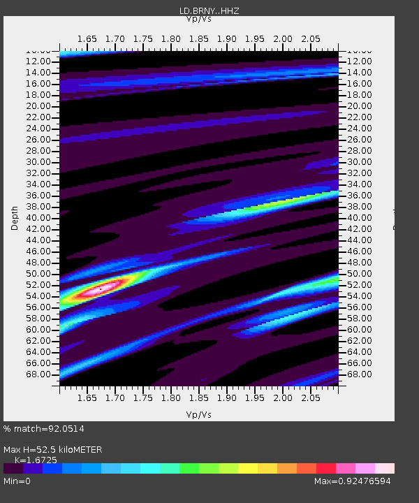
| Estimated Moho Depth: |
52.5 km |
| Estimated Crust Vp/Vs: |
1.67 |
| Assumed Crust Vp: |
6.283 km/s |
| Estimated Crust Vs: |
3.757 km/s |
| Estimated Crust Poisson's Ratio: |
0.22 |
|
| Radial Match: |
92.0514 % |
| Radial Bump: |
159 |
| Transverse Match: |
70.11432 % |
| Transverse Bump: |
382 |
| SOD ConfigId: |
11737051 |
| Insert Time: |
2019-04-26 03:50:10.353 +0000 |
| GWidth: |
2.5 |
| Max Bumps: |
400 |
| Tol: |
0.001 |
|

Signal To Noise
| Channel | StoN | STA | LTA |
| LD:BRNY: :HHZ:20161124T18:49:45.199995Z | 15.2158 | 6.8022537E-6 | 4.47052E-7 |
| LD:BRNY: :HHN:20161124T18:49:45.199995Z | 9.512653 | 3.1508396E-6 | 3.3122615E-7 |
| LD:BRNY: :HHE:20161124T18:49:45.199995Z | 4.7747293 | 2.3878051E-6 | 5.0009226E-7 |
| Arrivals |
| Ps | 6.1 SECOND |
| PpPs | 21 SECOND |
| PsPs/PpSs | 27 SECOND |


