You are here: Home > Network List > BK - Berkeley Digital Seismograph Network Stations List
> Station WDC Whiskeytown, CA > Earthquake Result Viewer
WDC Whiskeytown, CA - Earthquake Result Viewer

| Earthquake location: |
Mariana Islands Region |
| Earthquake latitude/longitude: |
19.6/146.8 |
| Earthquake time(UTC): |
2004/07/20 (202) 14:16:23 GMT |
| Earthquake Depth: |
13 km |
| Earthquake Magnitude: |
5.7 MB, 5.6 MS, 5.9 MW, 5.9 MW |
| Earthquake Catalog/Contributor: |
WHDF/NEIC |
|
| Network: |
BK Berkeley Digital Seismograph Network |
| Station: |
WDC Whiskeytown, CA |
| Lat/Lon: |
40.58 N/122.54 W |
| Elevation: |
268 m |
|
| Distance: |
78.0 deg |
| Az: |
51.141 deg |
| Baz: |
285.502 deg |
| Ray Param: |
0.049950358 |
| Estimated Moho Depth: |
24.25 km |
| Estimated Crust Vp/Vs: |
1.77 |
| Assumed Crust Vp: |
6.566 km/s |
| Estimated Crust Vs: |
3.71 km/s |
| Estimated Crust Poisson's Ratio: |
0.27 |
|
| Radial Match: |
84.514854 % |
| Radial Bump: |
400 |
| Transverse Match: |
82.71484 % |
| Transverse Bump: |
400 |
| SOD ConfigId: |
124340 |
| Insert Time: |
2010-03-05 19:59:47.079 +0000 |
| GWidth: |
2.5 |
| Max Bumps: |
400 |
| Tol: |
0.001 |
|
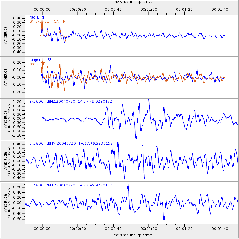
Signal To Noise
| Channel | StoN | STA | LTA |
| BK:WDC: :BHN:20040720T14:27:49.923015Z | 2.2120347 | 1.0282715E-7 | 4.6485322E-8 |
| BK:WDC: :BHE:20040720T14:27:49.923015Z | 0.83681494 | 5.224589E-8 | 6.2434225E-8 |
| BK:WDC: :BHZ:20040720T14:27:49.923015Z | 2.5812142 | 2.0405467E-7 | 7.9053756E-8 |
| Arrivals |
| Ps | 2.9 SECOND |
| PpPs | 9.9 SECOND |
| PsPs/PpSs | 13 SECOND |


