You are here: Home > Network List > LD - Lamont-Doherty Cooperative Seismographic Network Stations List
> Station UNH University of New Hampshire, Durham, NH, USA > Earthquake Result Viewer
UNH University of New Hampshire, Durham, NH, USA - Earthquake Result Viewer
| Earthquake location: |
Off Coast Of Central America |
| Earthquake latitude/longitude: |
12.0/-88.8 |
| Earthquake time(UTC): |
2016/11/24 (329) 18:43:48 GMT |
| Earthquake Depth: |
10 km |
| Earthquake Magnitude: |
7.0 MWW, 6.7 MWB, 7.2 MI |
| Earthquake Catalog/Contributor: |
NEIC PDE/NEIC COMCAT |
|
| Network: |
LD Lamont-Doherty Cooperative Seismographic Network |
| Station: |
UNH University of New Hampshire, Durham, NH, USA |
| Lat/Lon: |
43.09 N/70.87 W |
| Elevation: |
5.0 m |
|
| Distance: |
34.7 deg |
| Az: |
23.384 deg |
| Baz: |
212.018 deg |
| Ray Param: |
0.07759947 |
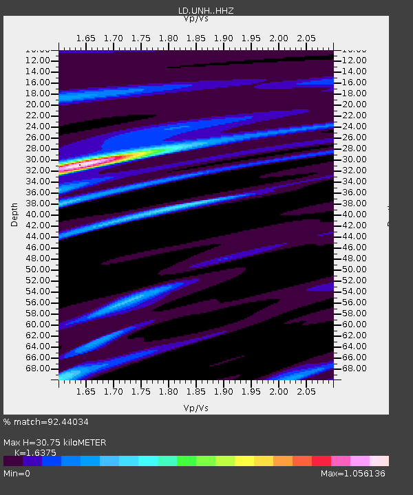
| Estimated Moho Depth: |
30.75 km |
| Estimated Crust Vp/Vs: |
1.64 |
| Assumed Crust Vp: |
6.419 km/s |
| Estimated Crust Vs: |
3.92 km/s |
| Estimated Crust Poisson's Ratio: |
0.20 |
|
| Radial Match: |
92.44034 % |
| Radial Bump: |
311 |
| Transverse Match: |
63.14998 % |
| Transverse Bump: |
393 |
| SOD ConfigId: |
11737051 |
| Insert Time: |
2019-04-26 03:50:27.711 +0000 |
| GWidth: |
2.5 |
| Max Bumps: |
400 |
| Tol: |
0.001 |
|

Signal To Noise
| Channel | StoN | STA | LTA |
| LD:UNH: :HHZ:20161124T18:50:07.984999Z | 12.645805 | 6.006122E-6 | 4.7494976E-7 |
| LD:UNH: :HHN:20161124T18:50:07.984999Z | 5.940862 | 4.0132045E-6 | 6.755256E-7 |
| LD:UNH: :HHE:20161124T18:50:07.984999Z | 3.8521037 | 1.7704683E-6 | 4.5961076E-7 |
| Arrivals |
| Ps | 3.3 SECOND |
| PpPs | 12 SECOND |
| PsPs/PpSs | 15 SECOND |


