You are here: Home > Network List > N4 - Central and EAstern US Network Stations List
> Station L42A Oliver, Polo, IL, USA > Earthquake Result Viewer
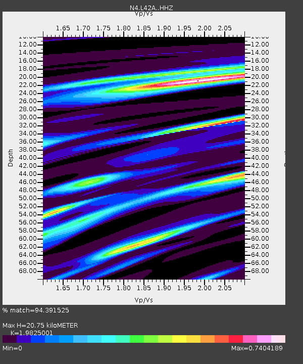
L42A Oliver, Polo, IL, USA - Earthquake Result Viewer
| Earthquake location: |
Off Coast Of Central America |
| Earthquake latitude/longitude: |
12.0/-88.8 |
| Earthquake time(UTC): |
2016/11/24 (329) 18:43:48 GMT |
| Earthquake Depth: |
10 km |
| Earthquake Magnitude: |
7.0 MWW, 6.7 MWB, 7.2 MI |
| Earthquake Catalog/Contributor: |
NEIC PDE/NEIC COMCAT |
|
| Network: |
N4 Central and EAstern US Network |
| Station: |
L42A Oliver, Polo, IL, USA |
| Lat/Lon: |
42.00 N/89.67 W |
| Elevation: |
257 m |
|
| Distance: |
29.9 deg |
| Az: |
358.758 deg |
| Baz: |
178.369 deg |
| Ray Param: |
0.07946264 |
| Estimated Moho Depth: |
20.75 km |
| Estimated Crust Vp/Vs: |
1.98 |
| Assumed Crust Vp: |
6.571 km/s |
| Estimated Crust Vs: |
3.314 km/s |
| Estimated Crust Poisson's Ratio: |
0.33 |
|
| Radial Match: |
94.391525 % |
| Radial Bump: |
273 |
| Transverse Match: |
61.735493 % |
| Transverse Bump: |
400 |
| SOD ConfigId: |
11737051 |
| Insert Time: |
2019-04-26 03:51:14.457 +0000 |
| GWidth: |
2.5 |
| Max Bumps: |
400 |
| Tol: |
0.001 |
|

Signal To Noise
| Channel | StoN | STA | LTA |
| N4:L42A: :HHZ:20161124T18:49:26.300001Z | 17.236261 | 8.661102E-6 | 5.0249304E-7 |
| N4:L42A: :HHN:20161124T18:49:26.300001Z | 14.106885 | 5.825177E-6 | 4.129315E-7 |
| N4:L42A: :HHE:20161124T18:49:26.300001Z | 1.3551565 | 4.585134E-7 | 3.383472E-7 |
| Arrivals |
| Ps | 3.3 SECOND |
| PpPs | 8.7 SECOND |
| PsPs/PpSs | 12 SECOND |


