You are here: Home > Network List > GS - US Geological Survey Networks Stations List
> Station KAN13 Rinehart Farm, , CA, USA > Earthquake Result Viewer
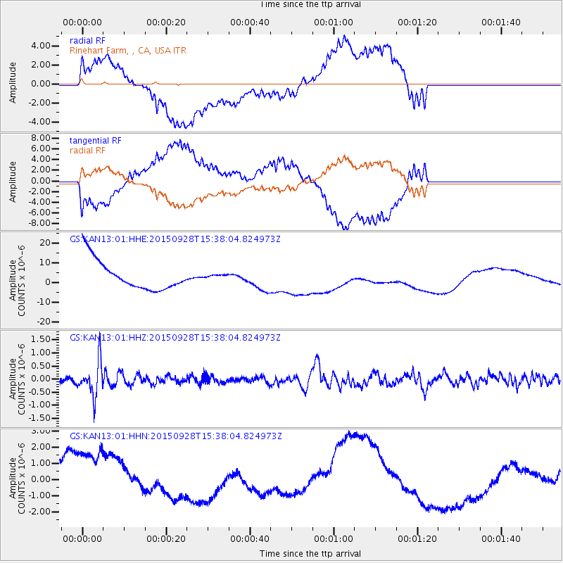
KAN13 Rinehart Farm, , CA, USA - Earthquake Result Viewer
*The percent match for this event was below the threshold and hence no stack was calculated.
| Earthquake location: |
Jujuy Province, Argentina |
| Earthquake latitude/longitude: |
-23.8/-66.6 |
| Earthquake time(UTC): |
2015/09/28 (271) 15:28:05 GMT |
| Earthquake Depth: |
219 km |
| Earthquake Magnitude: |
5.9 MWW, 6.0 MWB, 6.0 MWC |
| Earthquake Catalog/Contributor: |
NEIC PDE/NEIC COMCAT |
|
| Network: |
GS US Geological Survey Networks |
| Station: |
KAN13 Rinehart Farm, , CA, USA |
| Lat/Lon: |
37.01 N/97.48 W |
| Elevation: |
340 m |
|
| Distance: |
67.1 deg |
| Az: |
333.509 deg |
| Baz: |
149.306 deg |
| Ray Param: |
$rayparam |
*The percent match for this event was below the threshold and hence was not used in the summary stack. |
|
| Radial Match: |
50.877583 % |
| Radial Bump: |
400 |
| Transverse Match: |
51.295567 % |
| Transverse Bump: |
400 |
| SOD ConfigId: |
1259291 |
| Insert Time: |
2015-11-02 23:16:59.119 +0000 |
| GWidth: |
2.5 |
| Max Bumps: |
400 |
| Tol: |
0.001 |
|
Signal To Noise
| Channel | StoN | STA | LTA |
| GS:KAN13:01:HHZ:20150928T15:38:04.824973Z | 5.354224 | 6.717863E-7 | 1.2546847E-7 |
| GS:KAN13:01:HHN:20150928T15:38:04.824973Z | 2.2478878 | 2.5770805E-6 | 1.1464454E-6 |
| GS:KAN13:01:HHE:20150928T15:38:04.824973Z | 0.12470729 | 9.340177E-7 | 7.48968E-6 |
| Arrivals |
| Ps | |
| PpPs | |
| PsPs/PpSs | |


