You are here: Home > Network List > TA - USArray Transportable Network (new EarthScope stations) Stations List
> Station C36M Paulatuk, NT, CAN > Earthquake Result Viewer
C36M Paulatuk, NT, CAN - Earthquake Result Viewer
| Earthquake location: |
Off Coast Of Central America |
| Earthquake latitude/longitude: |
12.0/-88.8 |
| Earthquake time(UTC): |
2016/11/24 (329) 18:43:48 GMT |
| Earthquake Depth: |
10 km |
| Earthquake Magnitude: |
7.0 MWW, 6.7 MWB, 7.2 MI |
| Earthquake Catalog/Contributor: |
NEIC PDE/NEIC COMCAT |
|
| Network: |
TA USArray Transportable Network (new EarthScope stations) |
| Station: |
C36M Paulatuk, NT, CAN |
| Lat/Lon: |
69.35 N/124.07 W |
| Elevation: |
10 m |
|
| Distance: |
61.6 deg |
| Az: |
346.541 deg |
| Baz: |
140.06 deg |
| Ray Param: |
0.06078837 |
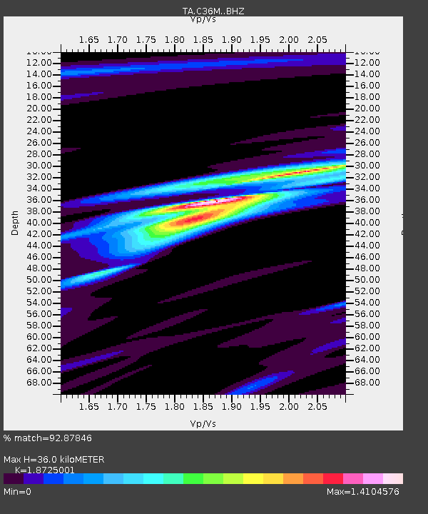
| Estimated Moho Depth: |
36.0 km |
| Estimated Crust Vp/Vs: |
1.87 |
| Assumed Crust Vp: |
6.459 km/s |
| Estimated Crust Vs: |
3.45 km/s |
| Estimated Crust Poisson's Ratio: |
0.30 |
|
| Radial Match: |
92.87846 % |
| Radial Bump: |
320 |
| Transverse Match: |
73.83663 % |
| Transverse Bump: |
400 |
| SOD ConfigId: |
11737051 |
| Insert Time: |
2019-04-26 03:53:38.388 +0000 |
| GWidth: |
2.5 |
| Max Bumps: |
400 |
| Tol: |
0.001 |
|

Signal To Noise
| Channel | StoN | STA | LTA |
| TA:C36M: :BHZ:20161124T18:53:34.999006Z | 13.641543 | 5.6804647E-6 | 4.1640925E-7 |
| TA:C36M: :BHN:20161124T18:53:34.999006Z | 9.36913 | 2.0592383E-6 | 2.1978971E-7 |
| TA:C36M: :BHE:20161124T18:53:34.999006Z | 10.912877 | 2.8660095E-6 | 2.626264E-7 |
| Arrivals |
| Ps | 5.1 SECOND |
| PpPs | 15 SECOND |
| PsPs/PpSs | 20 SECOND |


