You are here: Home > Network List > TA - USArray Transportable Network (new EarthScope stations) Stations List
> Station H21K Melozitna River, AK, USA > Earthquake Result Viewer
H21K Melozitna River, AK, USA - Earthquake Result Viewer
| Earthquake location: |
Off Coast Of Central America |
| Earthquake latitude/longitude: |
12.0/-88.8 |
| Earthquake time(UTC): |
2016/11/24 (329) 18:43:48 GMT |
| Earthquake Depth: |
10 km |
| Earthquake Magnitude: |
7.0 MWW, 6.7 MWB, 7.2 MI |
| Earthquake Catalog/Contributor: |
NEIC PDE/NEIC COMCAT |
|
| Network: |
TA USArray Transportable Network (new EarthScope stations) |
| Station: |
H21K Melozitna River, AK, USA |
| Lat/Lon: |
65.66 N/152.80 W |
| Elevation: |
520 m |
|
| Distance: |
68.6 deg |
| Az: |
336.415 deg |
| Baz: |
109.157 deg |
| Ray Param: |
0.05621751 |
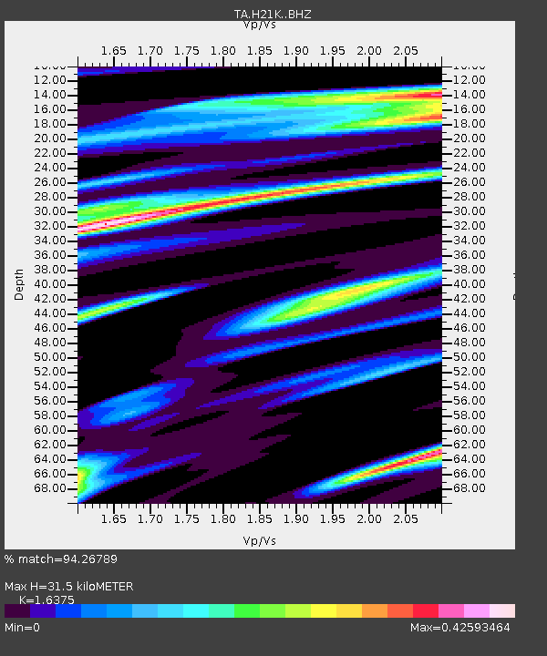
| Estimated Moho Depth: |
31.5 km |
| Estimated Crust Vp/Vs: |
1.64 |
| Assumed Crust Vp: |
6.566 km/s |
| Estimated Crust Vs: |
4.01 km/s |
| Estimated Crust Poisson's Ratio: |
0.20 |
|
| Radial Match: |
94.26789 % |
| Radial Bump: |
358 |
| Transverse Match: |
84.08594 % |
| Transverse Bump: |
400 |
| SOD ConfigId: |
11737051 |
| Insert Time: |
2019-04-26 03:53:56.440 +0000 |
| GWidth: |
2.5 |
| Max Bumps: |
400 |
| Tol: |
0.001 |
|

Signal To Noise
| Channel | StoN | STA | LTA |
| TA:H21K: :BHZ:20161124T18:54:20.374983Z | 50.658775 | 6.9648427E-6 | 1.3748542E-7 |
| TA:H21K: :BHN:20161124T18:54:20.374983Z | 4.0797863 | 6.2502664E-7 | 1.5320083E-7 |
| TA:H21K: :BHE:20161124T18:54:20.374983Z | 12.224335 | 2.2828915E-6 | 1.8674974E-7 |
| Arrivals |
| Ps | 3.2 SECOND |
| PpPs | 12 SECOND |
| PsPs/PpSs | 15 SECOND |


