You are here: Home > Network List > TA - USArray Transportable Network (new EarthScope stations) Stations List
> Station N25K Chitina, Valdez-Cordova, AK, USA > Earthquake Result Viewer
N25K Chitina, Valdez-Cordova, AK, USA - Earthquake Result Viewer
| Earthquake location: |
Off Coast Of Central America |
| Earthquake latitude/longitude: |
12.0/-88.8 |
| Earthquake time(UTC): |
2016/11/24 (329) 18:43:48 GMT |
| Earthquake Depth: |
10 km |
| Earthquake Magnitude: |
7.0 MWW, 6.7 MWB, 7.2 MI |
| Earthquake Catalog/Contributor: |
NEIC PDE/NEIC COMCAT |
|
| Network: |
TA USArray Transportable Network (new EarthScope stations) |
| Station: |
N25K Chitina, Valdez-Cordova, AK, USA |
| Lat/Lon: |
61.61 N/144.60 W |
| Elevation: |
1087 m |
|
| Distance: |
63.6 deg |
| Az: |
333.83 deg |
| Baz: |
115.46 deg |
| Ray Param: |
0.05944613 |
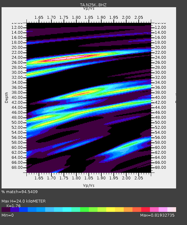
| Estimated Moho Depth: |
24.0 km |
| Estimated Crust Vp/Vs: |
1.76 |
| Assumed Crust Vp: |
6.566 km/s |
| Estimated Crust Vs: |
3.731 km/s |
| Estimated Crust Poisson's Ratio: |
0.26 |
|
| Radial Match: |
94.5409 % |
| Radial Bump: |
400 |
| Transverse Match: |
90.13062 % |
| Transverse Bump: |
400 |
| SOD ConfigId: |
11737051 |
| Insert Time: |
2019-04-26 03:54:38.590 +0000 |
| GWidth: |
2.5 |
| Max Bumps: |
400 |
| Tol: |
0.001 |
|
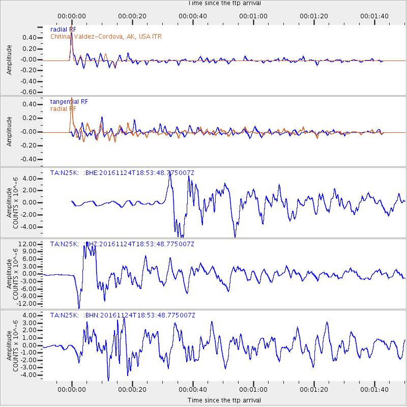
Signal To Noise
| Channel | StoN | STA | LTA |
| TA:N25K: :BHZ:20161124T18:53:48.775007Z | 46.92105 | 6.7221886E-6 | 1.4326594E-7 |
| TA:N25K: :BHN:20161124T18:53:48.775007Z | 4.34213 | 1.099257E-6 | 2.5316078E-7 |
| TA:N25K: :BHE:20161124T18:53:48.775007Z | 9.369388 | 2.6215055E-6 | 2.7979476E-7 |
| Arrivals |
| Ps | 2.9 SECOND |
| PpPs | 9.6 SECOND |
| PsPs/PpSs | 13 SECOND |


