You are here: Home > Network List > TA - USArray Transportable Network (new EarthScope stations) Stations List
> Station Q17K Contact Creek, Katmai, AK, USA > Earthquake Result Viewer
Q17K Contact Creek, Katmai, AK, USA - Earthquake Result Viewer

| Earthquake location: |
Off Coast Of Central America |
| Earthquake latitude/longitude: |
12.0/-88.8 |
| Earthquake time(UTC): |
2016/11/24 (329) 18:43:48 GMT |
| Earthquake Depth: |
10 km |
| Earthquake Magnitude: |
7.0 MWW, 6.7 MWB, 7.2 MI |
| Earthquake Catalog/Contributor: |
NEIC PDE/NEIC COMCAT |
|
| Network: |
TA USArray Transportable Network (new EarthScope stations) |
| Station: |
Q17K Contact Creek, Katmai, AK, USA |
| Lat/Lon: |
58.26 N/155.89 W |
| Elevation: |
1165 m |
|
| Distance: |
67.9 deg |
| Az: |
328.306 deg |
| Baz: |
103.424 deg |
| Ray Param: |
0.05666424 |
| Estimated Moho Depth: |
35.75 km |
| Estimated Crust Vp/Vs: |
1.60 |
| Assumed Crust Vp: |
6.438 km/s |
| Estimated Crust Vs: |
4.024 km/s |
| Estimated Crust Poisson's Ratio: |
0.18 |
|
| Radial Match: |
92.461205 % |
| Radial Bump: |
400 |
| Transverse Match: |
88.636406 % |
| Transverse Bump: |
400 |
| SOD ConfigId: |
11737051 |
| Insert Time: |
2019-04-26 03:54:55.539 +0000 |
| GWidth: |
2.5 |
| Max Bumps: |
400 |
| Tol: |
0.001 |
|
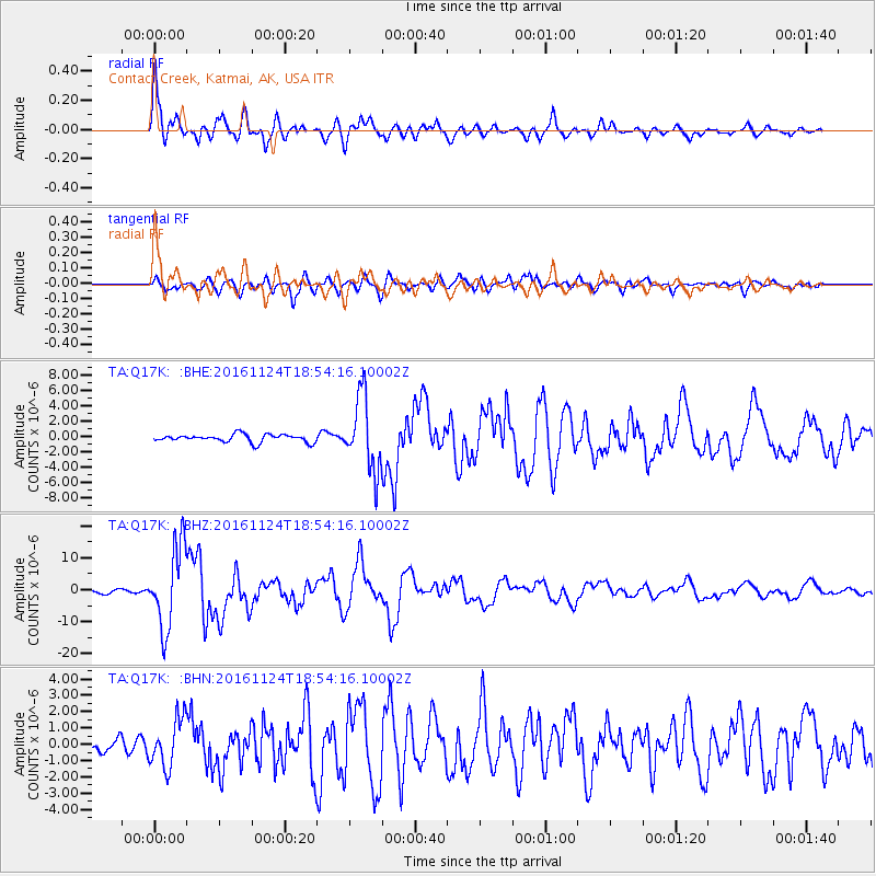
Signal To Noise
| Channel | StoN | STA | LTA |
| TA:Q17K: :BHZ:20161124T18:54:16.10002Z | 19.688713 | 1.2739254E-5 | 6.4703335E-7 |
| TA:Q17K: :BHN:20161124T18:54:16.10002Z | 3.605302 | 1.4741383E-6 | 4.0888065E-7 |
| TA:Q17K: :BHE:20161124T18:54:16.10002Z | 9.333714 | 4.6955374E-6 | 5.0307284E-7 |
| Arrivals |
| Ps | 3.5 SECOND |
| PpPs | 14 SECOND |
| PsPs/PpSs | 17 SECOND |


