You are here: Home > Network List > TA - USArray Transportable Network (new EarthScope stations) Stations List
> Station R11A Troy Canyon, Currant, NV, USA > Earthquake Result Viewer
R11A Troy Canyon, Currant, NV, USA - Earthquake Result Viewer

| Earthquake location: |
Off Coast Of Central America |
| Earthquake latitude/longitude: |
12.0/-88.8 |
| Earthquake time(UTC): |
2016/11/24 (329) 18:43:48 GMT |
| Earthquake Depth: |
10 km |
| Earthquake Magnitude: |
7.0 MWW, 6.7 MWB, 7.2 MI |
| Earthquake Catalog/Contributor: |
NEIC PDE/NEIC COMCAT |
|
| Network: |
TA USArray Transportable Network (new EarthScope stations) |
| Station: |
R11A Troy Canyon, Currant, NV, USA |
| Lat/Lon: |
38.35 N/115.59 W |
| Elevation: |
1756 m |
|
| Distance: |
35.5 deg |
| Az: |
322.432 deg |
| Baz: |
130.64 deg |
| Ray Param: |
0.077199124 |
| Estimated Moho Depth: |
16.75 km |
| Estimated Crust Vp/Vs: |
1.64 |
| Assumed Crust Vp: |
6.276 km/s |
| Estimated Crust Vs: |
3.821 km/s |
| Estimated Crust Poisson's Ratio: |
0.21 |
|
| Radial Match: |
92.965096 % |
| Radial Bump: |
363 |
| Transverse Match: |
69.59106 % |
| Transverse Bump: |
400 |
| SOD ConfigId: |
11737051 |
| Insert Time: |
2019-04-26 03:55:03.042 +0000 |
| GWidth: |
2.5 |
| Max Bumps: |
400 |
| Tol: |
0.001 |
|
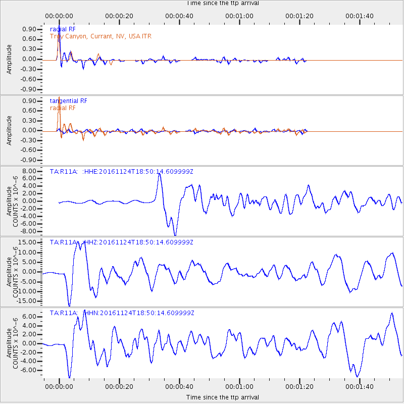
Signal To Noise
| Channel | StoN | STA | LTA |
| TA:R11A: :HHZ:20161124T18:50:14.609999Z | 26.896116 | 7.6268343E-6 | 2.8356638E-7 |
| TA:R11A: :HHN:20161124T18:50:14.609999Z | 11.825302 | 3.3264005E-6 | 2.8129517E-7 |
| TA:R11A: :HHE:20161124T18:50:14.609999Z | 12.1842785 | 3.4055122E-6 | 2.795005E-7 |
| Arrivals |
| Ps | 1.9 SECOND |
| PpPs | 6.5 SECOND |
| PsPs/PpSs | 8.4 SECOND |


