You are here: Home > Network List > TA - USArray Transportable Network (new EarthScope stations) Stations List
> Station TPFO Pinon Flats, CA, USA > Earthquake Result Viewer
TPFO Pinon Flats, CA, USA - Earthquake Result Viewer
| Earthquake location: |
Off Coast Of Central America |
| Earthquake latitude/longitude: |
12.0/-88.8 |
| Earthquake time(UTC): |
2016/11/24 (329) 18:43:48 GMT |
| Earthquake Depth: |
10 km |
| Earthquake Magnitude: |
7.0 MWW, 6.7 MWB, 7.2 MI |
| Earthquake Catalog/Contributor: |
NEIC PDE/NEIC COMCAT |
|
| Network: |
TA USArray Transportable Network (new EarthScope stations) |
| Station: |
TPFO Pinon Flats, CA, USA |
| Lat/Lon: |
33.61 N/116.45 W |
| Elevation: |
1275 m |
|
| Distance: |
33.2 deg |
| Az: |
314.996 deg |
| Baz: |
123.986 deg |
| Ray Param: |
0.07833056 |
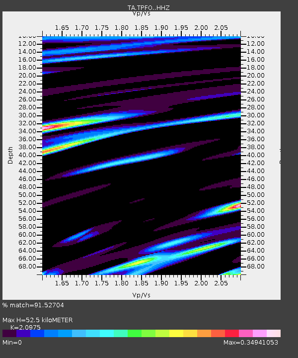
| Estimated Moho Depth: |
52.5 km |
| Estimated Crust Vp/Vs: |
2.10 |
| Assumed Crust Vp: |
6.264 km/s |
| Estimated Crust Vs: |
2.986 km/s |
| Estimated Crust Poisson's Ratio: |
0.35 |
|
| Radial Match: |
91.52704 % |
| Radial Bump: |
312 |
| Transverse Match: |
80.59192 % |
| Transverse Bump: |
400 |
| SOD ConfigId: |
11737051 |
| Insert Time: |
2019-04-26 03:55:13.914 +0000 |
| GWidth: |
2.5 |
| Max Bumps: |
400 |
| Tol: |
0.001 |
|
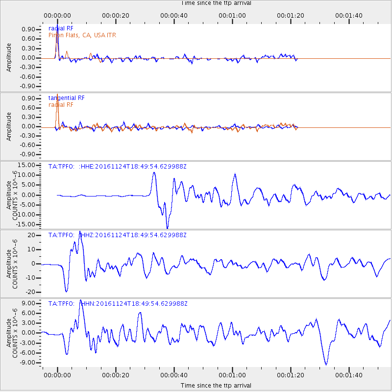
Signal To Noise
| Channel | StoN | STA | LTA |
| TA:TPFO: :HHZ:20161124T18:49:54.629988Z | 32.830143 | 9.053348E-6 | 2.7576328E-7 |
| TA:TPFO: :HHN:20161124T18:49:54.629988Z | 13.499048 | 2.7671747E-6 | 2.0499036E-7 |
| TA:TPFO: :HHE:20161124T18:49:54.629988Z | 25.011011 | 5.423371E-6 | 2.1683933E-7 |
| Arrivals |
| Ps | 9.8 SECOND |
| PpPs | 24 SECOND |
| PsPs/PpSs | 34 SECOND |


