You are here: Home > Network List > TA - USArray Transportable Network (new EarthScope stations) Stations List
> Station T33K Petersburg, AK, USA > Earthquake Result Viewer
T33K Petersburg, AK, USA - Earthquake Result Viewer

| Earthquake location: |
Off Coast Of Central America |
| Earthquake latitude/longitude: |
12.0/-88.8 |
| Earthquake time(UTC): |
2016/11/24 (329) 18:43:48 GMT |
| Earthquake Depth: |
10 km |
| Earthquake Magnitude: |
7.0 MWW, 6.7 MWB, 7.2 MI |
| Earthquake Catalog/Contributor: |
NEIC PDE/NEIC COMCAT |
|
| Network: |
TA USArray Transportable Network (new EarthScope stations) |
| Station: |
T33K Petersburg, AK, USA |
| Lat/Lon: |
56.81 N/132.95 W |
| Elevation: |
22 m |
|
| Distance: |
56.1 deg |
| Az: |
332.52 deg |
| Baz: |
124.805 deg |
| Ray Param: |
0.064386904 |
| Estimated Moho Depth: |
39.75 km |
| Estimated Crust Vp/Vs: |
1.60 |
| Assumed Crust Vp: |
6.597 km/s |
| Estimated Crust Vs: |
4.117 km/s |
| Estimated Crust Poisson's Ratio: |
0.18 |
|
| Radial Match: |
90.85105 % |
| Radial Bump: |
400 |
| Transverse Match: |
78.61742 % |
| Transverse Bump: |
400 |
| SOD ConfigId: |
11737051 |
| Insert Time: |
2019-04-26 03:55:13.989 +0000 |
| GWidth: |
2.5 |
| Max Bumps: |
400 |
| Tol: |
0.001 |
|
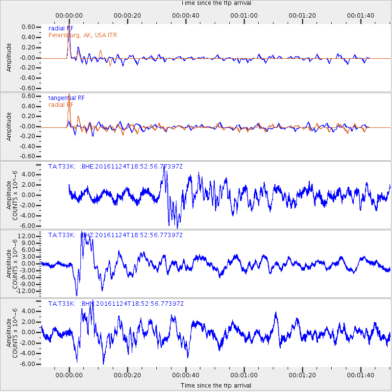
Signal To Noise
| Channel | StoN | STA | LTA |
| TA:T33K: :BHZ:20161124T18:52:56.77397Z | 8.839093 | 6.3928524E-6 | 7.232475E-7 |
| TA:T33K: :BHN:20161124T18:52:56.77397Z | 2.8161979 | 2.4133844E-6 | 8.5696547E-7 |
| TA:T33K: :BHE:20161124T18:52:56.77397Z | 3.3410428 | 2.7196095E-6 | 8.140002E-7 |
| Arrivals |
| Ps | 3.9 SECOND |
| PpPs | 15 SECOND |
| PsPs/PpSs | 19 SECOND |


