You are here: Home > Network List > UW - Pacific Northwest Regional Seismic Network Stations List
> Station LEBA Lebam, WA, USA > Earthquake Result Viewer
LEBA Lebam, WA, USA - Earthquake Result Viewer
*The percent match for this event was below the threshold and hence no stack was calculated.
| Earthquake location: |
Off Coast Of Central America |
| Earthquake latitude/longitude: |
12.0/-88.8 |
| Earthquake time(UTC): |
2016/11/24 (329) 18:43:48 GMT |
| Earthquake Depth: |
10 km |
| Earthquake Magnitude: |
7.0 MWW, 6.7 MWB, 7.2 MI |
| Earthquake Catalog/Contributor: |
NEIC PDE/NEIC COMCAT |
|
| Network: |
UW Pacific Northwest Regional Seismic Network |
| Station: |
LEBA Lebam, WA, USA |
| Lat/Lon: |
46.55 N/123.56 W |
| Elevation: |
73 m |
|
| Distance: |
45.2 deg |
| Az: |
326.378 deg |
| Baz: |
128.275 deg |
| Ray Param: |
$rayparam |
*The percent match for this event was below the threshold and hence was not used in the summary stack. |
|
| Radial Match: |
78.4501 % |
| Radial Bump: |
400 |
| Transverse Match: |
67.222565 % |
| Transverse Bump: |
400 |
| SOD ConfigId: |
11737051 |
| Insert Time: |
2019-04-26 03:56:25.547 +0000 |
| GWidth: |
2.5 |
| Max Bumps: |
400 |
| Tol: |
0.001 |
|
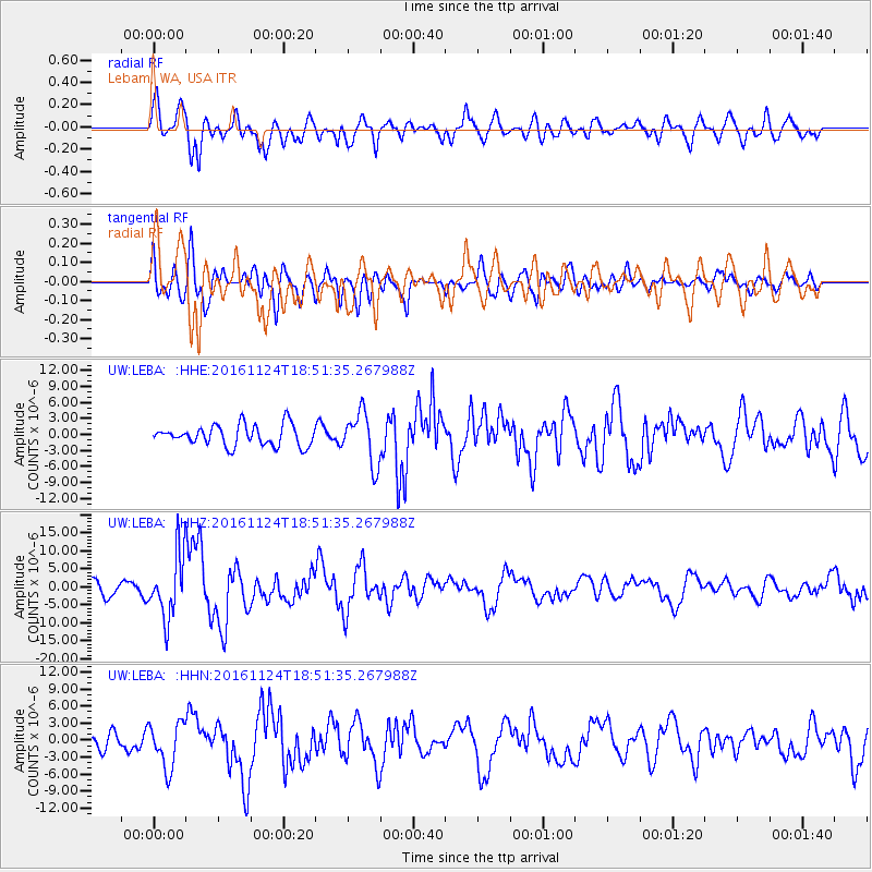
Signal To Noise
| Channel | StoN | STA | LTA |
| UW:LEBA: :HHZ:20161124T18:51:35.267988Z | 4.9812307 | 8.830848E-6 | 1.7728246E-6 |
| UW:LEBA: :HHN:20161124T18:51:35.267988Z | 2.2859213 | 3.9784445E-6 | 1.7404117E-6 |
| UW:LEBA: :HHE:20161124T18:51:35.267988Z | 2.4688015 | 4.7955095E-6 | 1.9424444E-6 |
| Arrivals |
| Ps | |
| PpPs | |
| PsPs/PpSs | |


