You are here: Home > Network List > YT07 - POLENET Stations List
> Station KOLR KOLR > Earthquake Result Viewer
KOLR KOLR - Earthquake Result Viewer
| Earthquake location: |
Off Coast Of Central America |
| Earthquake latitude/longitude: |
12.0/-88.8 |
| Earthquake time(UTC): |
2016/11/24 (329) 18:43:48 GMT |
| Earthquake Depth: |
10 km |
| Earthquake Magnitude: |
7.0 MWW, 6.7 MWB, 7.2 MI |
| Earthquake Catalog/Contributor: |
NEIC PDE/NEIC COMCAT |
|
| Network: |
YT POLENET |
| Station: |
KOLR KOLR |
| Lat/Lon: |
76.15 S/120.73 W |
| Elevation: |
1888 m |
|
| Distance: |
90.0 deg |
| Az: |
187.31 deg |
| Baz: |
31.131 deg |
| Ray Param: |
0.041705612 |
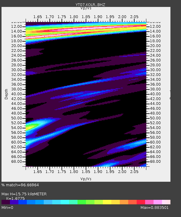
| Estimated Moho Depth: |
15.75 km |
| Estimated Crust Vp/Vs: |
1.68 |
| Assumed Crust Vp: |
6.095 km/s |
| Estimated Crust Vs: |
3.633 km/s |
| Estimated Crust Poisson's Ratio: |
0.22 |
|
| Radial Match: |
96.66964 % |
| Radial Bump: |
386 |
| Transverse Match: |
95.29557 % |
| Transverse Bump: |
400 |
| SOD ConfigId: |
11737051 |
| Insert Time: |
2019-04-26 03:57:47.557 +0000 |
| GWidth: |
2.5 |
| Max Bumps: |
400 |
| Tol: |
0.001 |
|

Signal To Noise
| Channel | StoN | STA | LTA |
| YT:KOLR: :BHZ:20161124T18:56:16.723982Z | 30.677351 | 5.2350365E-6 | 1.7064825E-7 |
| YT:KOLR: :BHN:20161124T18:56:16.723982Z | 6.9409976 | 1.3450494E-6 | 1.9378331E-7 |
| YT:KOLR: :BHE:20161124T18:56:16.723982Z | 8.663553 | 1.130891E-6 | 1.305343E-7 |
| Arrivals |
| Ps | 1.8 SECOND |
| PpPs | 6.8 SECOND |
| PsPs/PpSs | 8.6 SECOND |


