You are here: Home > Network List > CI - Caltech Regional Seismic Network Stations List
> Station TIN Tinemaha, Big Pine, CA, USA > Earthquake Result Viewer
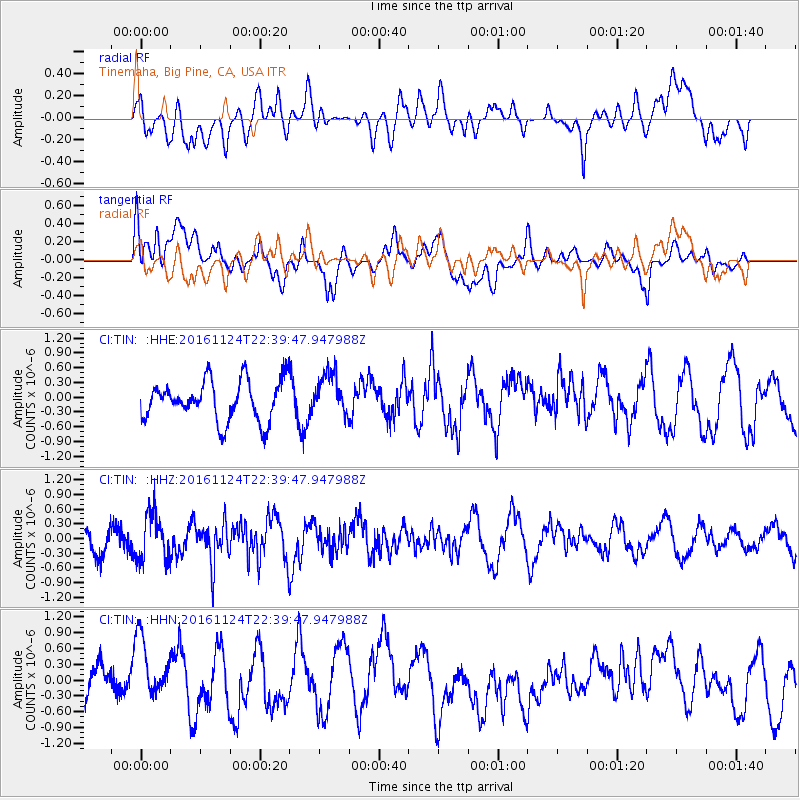
TIN Tinemaha, Big Pine, CA, USA - Earthquake Result Viewer
*The percent match for this event was below the threshold and hence no stack was calculated.
| Earthquake location: |
Komandorskiye Ostrova Region |
| Earthquake latitude/longitude: |
55.2/164.6 |
| Earthquake time(UTC): |
2016/11/24 (329) 22:31:01 GMT |
| Earthquake Depth: |
38 km |
| Earthquake Magnitude: |
5.5 MB |
| Earthquake Catalog/Contributor: |
NEIC PDE/NEIC COMCAT |
|
| Network: |
CI Caltech Regional Seismic Network |
| Station: |
TIN Tinemaha, Big Pine, CA, USA |
| Lat/Lon: |
37.05 N/118.23 W |
| Elevation: |
1197 m |
|
| Distance: |
53.6 deg |
| Az: |
75.733 deg |
| Baz: |
316.046 deg |
| Ray Param: |
$rayparam |
*The percent match for this event was below the threshold and hence was not used in the summary stack. |
|
| Radial Match: |
41.508644 % |
| Radial Bump: |
400 |
| Transverse Match: |
62.901333 % |
| Transverse Bump: |
400 |
| SOD ConfigId: |
11737051 |
| Insert Time: |
2019-04-26 04:00:03.873 +0000 |
| GWidth: |
2.5 |
| Max Bumps: |
400 |
| Tol: |
0.001 |
|
Signal To Noise
| Channel | StoN | STA | LTA |
| CI:TIN: :HHZ:20161124T22:39:47.947988Z | 2.0778892 | 4.835624E-7 | 2.3271808E-7 |
| CI:TIN: :HHN:20161124T22:39:47.947988Z | 1.897813 | 6.545E-7 | 3.4487067E-7 |
| CI:TIN: :HHE:20161124T22:39:47.947988Z | 1.0562599 | 4.4074346E-7 | 4.1726798E-7 |
| Arrivals |
| Ps | |
| PpPs | |
| PsPs/PpSs | |


