You are here: Home > Network List > US - United States National Seismic Network Stations List
> Station EGMT Eagleton, Montana, USA > Earthquake Result Viewer
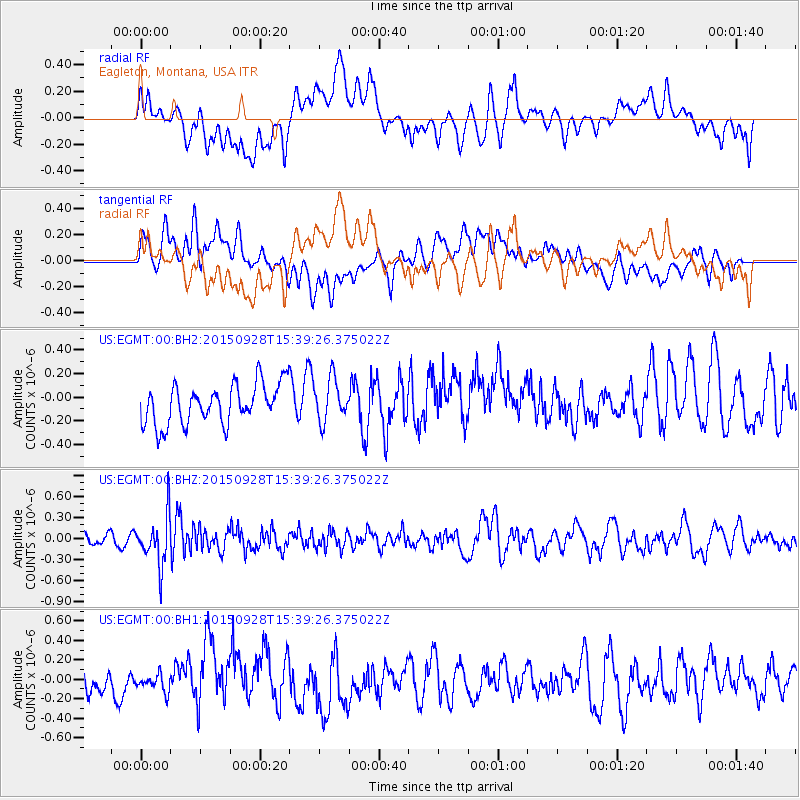
EGMT Eagleton, Montana, USA - Earthquake Result Viewer
*The percent match for this event was below the threshold and hence no stack was calculated.
| Earthquake location: |
Jujuy Province, Argentina |
| Earthquake latitude/longitude: |
-23.8/-66.6 |
| Earthquake time(UTC): |
2015/09/28 (271) 15:28:05 GMT |
| Earthquake Depth: |
219 km |
| Earthquake Magnitude: |
5.9 MWW, 6.0 MWB, 6.0 MWC |
| Earthquake Catalog/Contributor: |
NEIC PDE/NEIC COMCAT |
|
| Network: |
US United States National Seismic Network |
| Station: |
EGMT Eagleton, Montana, USA |
| Lat/Lon: |
48.02 N/109.75 W |
| Elevation: |
1055 m |
|
| Distance: |
81.3 deg |
| Az: |
332.315 deg |
| Baz: |
140.656 deg |
| Ray Param: |
$rayparam |
*The percent match for this event was below the threshold and hence was not used in the summary stack. |
|
| Radial Match: |
53.743164 % |
| Radial Bump: |
400 |
| Transverse Match: |
42.483223 % |
| Transverse Bump: |
400 |
| SOD ConfigId: |
1259291 |
| Insert Time: |
2015-11-02 23:22:26.372 +0000 |
| GWidth: |
2.5 |
| Max Bumps: |
400 |
| Tol: |
0.001 |
|
Signal To Noise
| Channel | StoN | STA | LTA |
| US:EGMT:00:BHZ:20150928T15:39:26.375022Z | 3.9134061 | 3.5319366E-7 | 9.0252236E-8 |
| US:EGMT:00:BH1:20150928T15:39:26.375022Z | 0.7340507 | 9.000926E-8 | 1.2261995E-7 |
| US:EGMT:00:BH2:20150928T15:39:26.375022Z | 1.0502396 | 1.7694472E-7 | 1.6848034E-7 |
| Arrivals |
| Ps | |
| PpPs | |
| PsPs/PpSs | |


