You are here: Home > Network List > NR - NARS Array Stations List
> Station NE217 Borolong > Earthquake Result Viewer
NE217 Borolong - Earthquake Result Viewer
| Earthquake location: |
Southern Xinjiang, China |
| Earthquake latitude/longitude: |
39.2/74.0 |
| Earthquake time(UTC): |
2016/11/25 (330) 14:24:29 GMT |
| Earthquake Depth: |
13 km |
| Earthquake Magnitude: |
6.6 MWW, 6.5 MWB, 6.6 MWC |
| Earthquake Catalog/Contributor: |
NEIC PDE/NEIC COMCAT |
|
| Network: |
NR NARS Array |
| Station: |
NE217 Borolong |
| Lat/Lon: |
21.10 S/27.33 E |
| Elevation: |
1047 m |
|
| Distance: |
74.2 deg |
| Az: |
224.934 deg |
| Baz: |
35.974 deg |
| Ray Param: |
0.052466977 |
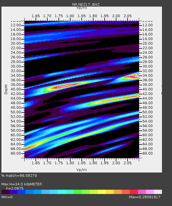
| Estimated Moho Depth: |
34.0 km |
| Estimated Crust Vp/Vs: |
2.10 |
| Assumed Crust Vp: |
6.459 km/s |
| Estimated Crust Vs: |
3.08 km/s |
| Estimated Crust Poisson's Ratio: |
0.35 |
|
| Radial Match: |
96.59278 % |
| Radial Bump: |
224 |
| Transverse Match: |
83.29231 % |
| Transverse Bump: |
400 |
| SOD ConfigId: |
11737051 |
| Insert Time: |
2019-04-26 04:21:40.522 +0000 |
| GWidth: |
2.5 |
| Max Bumps: |
400 |
| Tol: |
0.001 |
|

Signal To Noise
| Channel | StoN | STA | LTA |
| NR:NE217: :BHZ:20161125T14:35:35.078015Z | 6.42672 | 7.273019E-7 | 1.1316843E-7 |
| NR:NE217: :BHN:20161125T14:35:35.078015Z | 2.9860663 | 3.017717E-7 | 1.01059946E-7 |
| NR:NE217: :BHE:20161125T14:35:35.078015Z | 2.2030096 | 2.3802761E-7 | 1.0804656E-7 |
| Arrivals |
| Ps | 5.9 SECOND |
| PpPs | 16 SECOND |
| PsPs/PpSs | 22 SECOND |


