You are here: Home > Network List > TA - USArray Transportable Network (new EarthScope stations) Stations List
> Station A21K Barrow, AK, USA > Earthquake Result Viewer
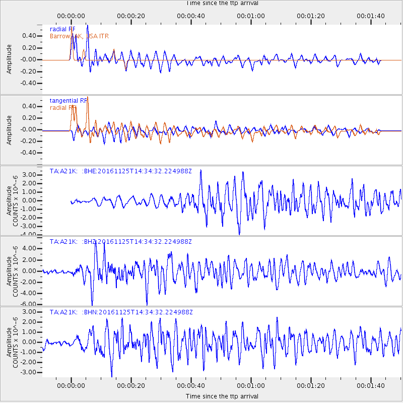
A21K Barrow, AK, USA - Earthquake Result Viewer
*The percent match for this event was below the threshold and hence no stack was calculated.
| Earthquake location: |
Southern Xinjiang, China |
| Earthquake latitude/longitude: |
39.2/74.0 |
| Earthquake time(UTC): |
2016/11/25 (330) 14:24:29 GMT |
| Earthquake Depth: |
13 km |
| Earthquake Magnitude: |
6.6 MWW, 6.5 MWB, 6.6 MWC |
| Earthquake Catalog/Contributor: |
NEIC PDE/NEIC COMCAT |
|
| Network: |
TA USArray Transportable Network (new EarthScope stations) |
| Station: |
A21K Barrow, AK, USA |
| Lat/Lon: |
71.32 N/156.62 W |
| Elevation: |
577 m |
|
| Distance: |
64.0 deg |
| Az: |
16.091 deg |
| Baz: |
318.08 deg |
| Ray Param: |
$rayparam |
*The percent match for this event was below the threshold and hence was not used in the summary stack. |
|
| Radial Match: |
80.73038 % |
| Radial Bump: |
400 |
| Transverse Match: |
79.40071 % |
| Transverse Bump: |
400 |
| SOD ConfigId: |
11737051 |
| Insert Time: |
2019-04-26 04:22:40.581 +0000 |
| GWidth: |
2.5 |
| Max Bumps: |
400 |
| Tol: |
0.001 |
|
Signal To Noise
| Channel | StoN | STA | LTA |
| TA:A21K: :BHZ:20161125T14:34:32.224988Z | 4.1938953 | 8.020661E-7 | 1.9124607E-7 |
| TA:A21K: :BHN:20161125T14:34:32.224988Z | 1.0978796 | 4.3346446E-7 | 3.9481964E-7 |
| TA:A21K: :BHE:20161125T14:34:32.224988Z | 1.4368579 | 4.632965E-7 | 3.2243722E-7 |
| Arrivals |
| Ps | |
| PpPs | |
| PsPs/PpSs | |


