You are here: Home > Network List > TA - USArray Transportable Network (new EarthScope stations) Stations List
> Station F31M Tsiigehtchic, NWT, CAN > Earthquake Result Viewer
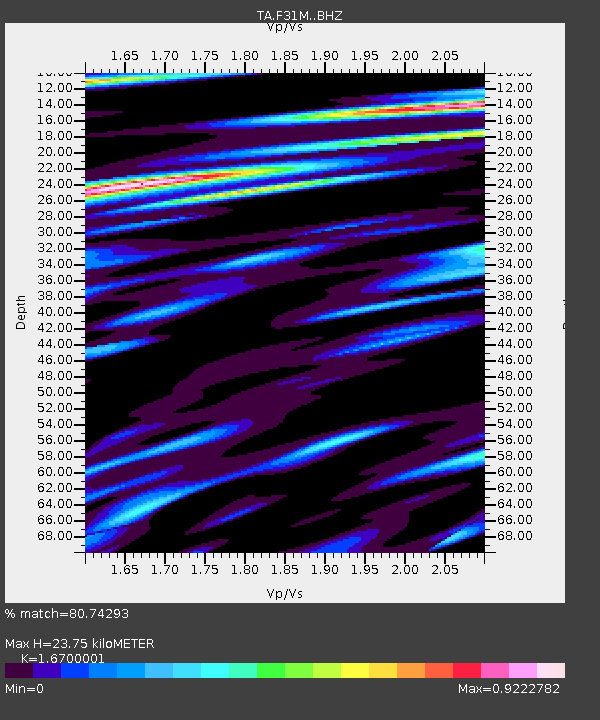
F31M Tsiigehtchic, NWT, CAN - Earthquake Result Viewer
| Earthquake location: |
Southern Xinjiang, China |
| Earthquake latitude/longitude: |
39.2/74.0 |
| Earthquake time(UTC): |
2016/11/25 (330) 14:24:29 GMT |
| Earthquake Depth: |
13 km |
| Earthquake Magnitude: |
6.6 MWW, 6.5 MWB, 6.6 MWC |
| Earthquake Catalog/Contributor: |
NEIC PDE/NEIC COMCAT |
|
| Network: |
TA USArray Transportable Network (new EarthScope stations) |
| Station: |
F31M Tsiigehtchic, NWT, CAN |
| Lat/Lon: |
67.44 N/133.74 W |
| Elevation: |
56 m |
|
| Distance: |
71.6 deg |
| Az: |
10.93 deg |
| Baz: |
337.565 deg |
| Ray Param: |
0.05423401 |
| Estimated Moho Depth: |
23.75 km |
| Estimated Crust Vp/Vs: |
1.67 |
| Assumed Crust Vp: |
6.171 km/s |
| Estimated Crust Vs: |
3.695 km/s |
| Estimated Crust Poisson's Ratio: |
0.22 |
|
| Radial Match: |
80.74293 % |
| Radial Bump: |
400 |
| Transverse Match: |
65.48789 % |
| Transverse Bump: |
400 |
| SOD ConfigId: |
11737051 |
| Insert Time: |
2019-04-26 04:22:50.339 +0000 |
| GWidth: |
2.5 |
| Max Bumps: |
400 |
| Tol: |
0.001 |
|

Signal To Noise
| Channel | StoN | STA | LTA |
| TA:F31M: :BHZ:20161125T14:35:19.550Z | 3.5144897 | 5.442794E-7 | 1.5486725E-7 |
| TA:F31M: :BHN:20161125T14:35:19.550Z | 1.0579364 | 2.62265E-7 | 2.4790242E-7 |
| TA:F31M: :BHE:20161125T14:35:19.550Z | 1.564026 | 2.5618854E-7 | 1.6380069E-7 |
| Arrivals |
| Ps | 2.7 SECOND |
| PpPs | 9.9 SECOND |
| PsPs/PpSs | 13 SECOND |


