You are here: Home > Network List > TA - USArray Transportable Network (new EarthScope stations) Stations List
> Station I23K Minto, Yukon-Koyukuk, AK, USA > Earthquake Result Viewer
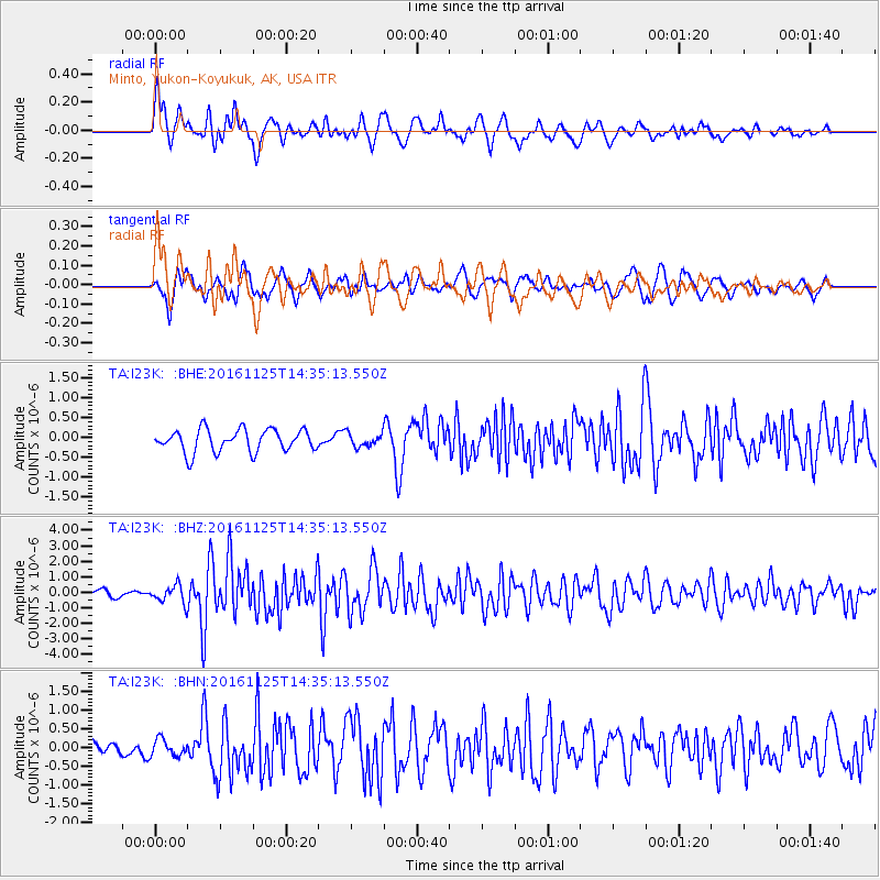
I23K Minto, Yukon-Koyukuk, AK, USA - Earthquake Result Viewer
*The percent match for this event was below the threshold and hence no stack was calculated.
| Earthquake location: |
Southern Xinjiang, China |
| Earthquake latitude/longitude: |
39.2/74.0 |
| Earthquake time(UTC): |
2016/11/25 (330) 14:24:29 GMT |
| Earthquake Depth: |
13 km |
| Earthquake Magnitude: |
6.6 MWW, 6.5 MWB, 6.6 MWC |
| Earthquake Catalog/Contributor: |
NEIC PDE/NEIC COMCAT |
|
| Network: |
TA USArray Transportable Network (new EarthScope stations) |
| Station: |
I23K Minto, Yukon-Koyukuk, AK, USA |
| Lat/Lon: |
65.15 N/149.36 W |
| Elevation: |
149 m |
|
| Distance: |
70.6 deg |
| Az: |
17.935 deg |
| Baz: |
325.537 deg |
| Ray Param: |
$rayparam |
*The percent match for this event was below the threshold and hence was not used in the summary stack. |
|
| Radial Match: |
72.341324 % |
| Radial Bump: |
400 |
| Transverse Match: |
69.21536 % |
| Transverse Bump: |
400 |
| SOD ConfigId: |
11737051 |
| Insert Time: |
2019-04-26 04:22:58.238 +0000 |
| GWidth: |
2.5 |
| Max Bumps: |
400 |
| Tol: |
0.001 |
|
Signal To Noise
| Channel | StoN | STA | LTA |
| TA:I23K: :BHZ:20161125T14:35:13.550Z | 2.8710866 | 5.762904E-7 | 2.0072207E-7 |
| TA:I23K: :BHN:20161125T14:35:13.550Z | 0.8170699 | 2.1966603E-7 | 2.688461E-7 |
| TA:I23K: :BHE:20161125T14:35:13.550Z | 0.5817051 | 1.6465147E-7 | 2.8304973E-7 |
| Arrivals |
| Ps | |
| PpPs | |
| PsPs/PpSs | |


