You are here: Home > Network List > TA - USArray Transportable Network (new EarthScope stations) Stations List
> Station N25K Chitina, Valdez-Cordova, AK, USA > Earthquake Result Viewer
N25K Chitina, Valdez-Cordova, AK, USA - Earthquake Result Viewer

| Earthquake location: |
Southern Xinjiang, China |
| Earthquake latitude/longitude: |
39.2/74.0 |
| Earthquake time(UTC): |
2016/11/25 (330) 14:24:29 GMT |
| Earthquake Depth: |
13 km |
| Earthquake Magnitude: |
6.6 MWW, 6.5 MWB, 6.6 MWC |
| Earthquake Catalog/Contributor: |
NEIC PDE/NEIC COMCAT |
|
| Network: |
TA USArray Transportable Network (new EarthScope stations) |
| Station: |
N25K Chitina, Valdez-Cordova, AK, USA |
| Lat/Lon: |
61.61 N/144.60 W |
| Elevation: |
1087 m |
|
| Distance: |
74.7 deg |
| Az: |
18.026 deg |
| Baz: |
329.818 deg |
| Ray Param: |
0.052134402 |
| Estimated Moho Depth: |
20.75 km |
| Estimated Crust Vp/Vs: |
1.90 |
| Assumed Crust Vp: |
6.566 km/s |
| Estimated Crust Vs: |
3.451 km/s |
| Estimated Crust Poisson's Ratio: |
0.31 |
|
| Radial Match: |
87.32053 % |
| Radial Bump: |
400 |
| Transverse Match: |
79.471375 % |
| Transverse Bump: |
400 |
| SOD ConfigId: |
11737051 |
| Insert Time: |
2019-04-26 04:23:11.647 +0000 |
| GWidth: |
2.5 |
| Max Bumps: |
400 |
| Tol: |
0.001 |
|
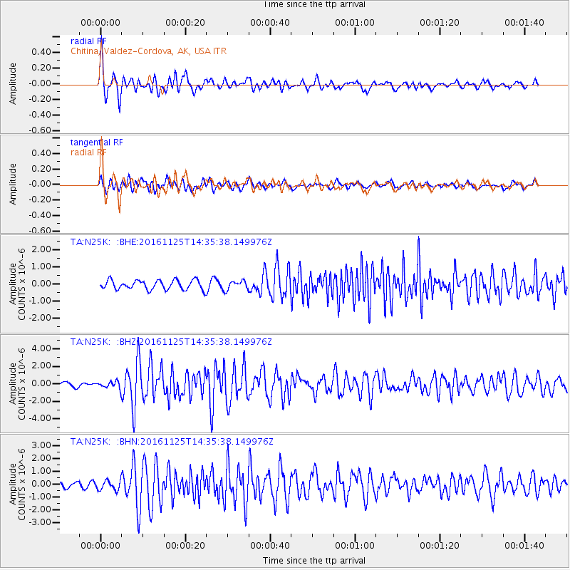
Signal To Noise
| Channel | StoN | STA | LTA |
| TA:N25K: :BHZ:20161125T14:35:38.149976Z | 1.6408328 | 4.0317636E-7 | 2.4571446E-7 |
| TA:N25K: :BHN:20161125T14:35:38.149976Z | 1.428753 | 3.8514636E-7 | 2.695682E-7 |
| TA:N25K: :BHE:20161125T14:35:38.149976Z | 1.0116855 | 2.687126E-7 | 2.6560883E-7 |
| Arrivals |
| Ps | 2.9 SECOND |
| PpPs | 8.9 SECOND |
| PsPs/PpSs | 12 SECOND |


