You are here: Home > Network List > CI - Caltech Regional Seismic Network Stations List
> Station MPP McPhearson Peak > Earthquake Result Viewer
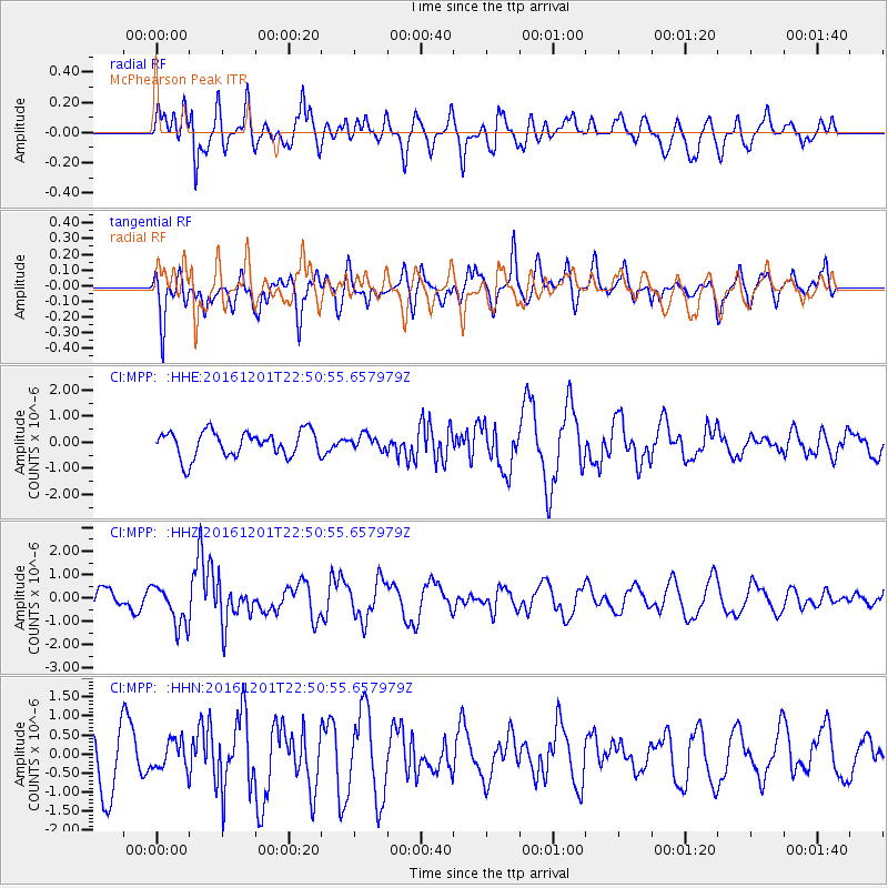
MPP McPhearson Peak - Earthquake Result Viewer
*The percent match for this event was below the threshold and hence no stack was calculated.
| Earthquake location: |
Southern Peru |
| Earthquake latitude/longitude: |
-15.3/-70.8 |
| Earthquake time(UTC): |
2016/12/01 (336) 22:40:26 GMT |
| Earthquake Depth: |
10 km |
| Earthquake Magnitude: |
6.3 Mww |
| Earthquake Catalog/Contributor: |
NEIC PDE/us |
|
| Network: |
CI Caltech Regional Seismic Network |
| Station: |
MPP McPhearson Peak |
| Lat/Lon: |
34.89 N/119.81 W |
| Elevation: |
1739 m |
|
| Distance: |
68.2 deg |
| Az: |
318.087 deg |
| Baz: |
128.364 deg |
| Ray Param: |
$rayparam |
*The percent match for this event was below the threshold and hence was not used in the summary stack. |
|
| Radial Match: |
45.375774 % |
| Radial Bump: |
400 |
| Transverse Match: |
61.05526 % |
| Transverse Bump: |
400 |
| SOD ConfigId: |
11737051 |
| Insert Time: |
2019-04-26 04:43:08.000 +0000 |
| GWidth: |
2.5 |
| Max Bumps: |
400 |
| Tol: |
0.001 |
|
Signal To Noise
| Channel | StoN | STA | LTA |
| CI:MPP: :HHZ:20161201T22:50:55.657979Z | 2.8122938 | 8.796198E-7 | 3.1277665E-7 |
| CI:MPP: :HHN:20161201T22:50:55.657979Z | 0.4955262 | 3.7615115E-7 | 7.590944E-7 |
| CI:MPP: :HHE:20161201T22:50:55.657979Z | 0.54914767 | 2.6982175E-7 | 4.9134644E-7 |
| Arrivals |
| Ps | |
| PpPs | |
| PsPs/PpSs | |


