You are here: Home > Network List > TA - USArray Transportable Network (new EarthScope stations) Stations List
> Station J26L Joseph Creek, AK, USA > Earthquake Result Viewer
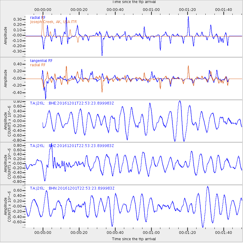
J26L Joseph Creek, AK, USA - Earthquake Result Viewer
*The percent match for this event was below the threshold and hence no stack was calculated.
| Earthquake location: |
Southern Peru |
| Earthquake latitude/longitude: |
-15.3/-70.8 |
| Earthquake time(UTC): |
2016/12/01 (336) 22:40:26 GMT |
| Earthquake Depth: |
10 km |
| Earthquake Magnitude: |
6.3 Mww |
| Earthquake Catalog/Contributor: |
NEIC PDE/us |
|
| Network: |
TA USArray Transportable Network (new EarthScope stations) |
| Station: |
J26L Joseph Creek, AK, USA |
| Lat/Lon: |
64.50 N/143.56 W |
| Elevation: |
1144 m |
|
| Distance: |
96.5 deg |
| Az: |
335.417 deg |
| Baz: |
111.97 deg |
| Ray Param: |
$rayparam |
*The percent match for this event was below the threshold and hence was not used in the summary stack. |
|
| Radial Match: |
50.41461 % |
| Radial Bump: |
271 |
| Transverse Match: |
66.80879 % |
| Transverse Bump: |
352 |
| SOD ConfigId: |
11737051 |
| Insert Time: |
2019-04-26 04:49:37.387 +0000 |
| GWidth: |
2.5 |
| Max Bumps: |
400 |
| Tol: |
0.001 |
|
Signal To Noise
| Channel | StoN | STA | LTA |
| TA:J26L: :BHZ:20161201T22:53:23.899983Z | 1.688785 | 4.861564E-7 | 2.878735E-7 |
| TA:J26L: :BHN:20161201T22:53:23.899983Z | 1.0484856 | 3.5754408E-7 | 3.4100998E-7 |
| TA:J26L: :BHE:20161201T22:53:23.899983Z | 0.5902524 | 1.7025977E-7 | 2.884525E-7 |
| Arrivals |
| Ps | |
| PpPs | |
| PsPs/PpSs | |


